|
|
| (같은 사용자의 중간 판 47개는 보이지 않습니다) |
| 1번째 줄: |
1번째 줄: |
| − | [[파일:33089668054_6631719387_b.jpg|300px]] | + | [[파일:33089668054_6631719387_b.jpg|400px]] |
| | [[파일:서울자전거 따릉이.png]] [https://www.bikeseoul.com/main.do/ 따릉이 공식웹페이지] | | [[파일:서울자전거 따릉이.png]] [https://www.bikeseoul.com/main.do/ 따릉이 공식웹페이지] |
| | | | |
| 11번째 줄: |
11번째 줄: |
| | | | |
| | ==이용방법== | | ==이용방법== |
| | + | <youtube>j2ysywRrKR4</youtube><br /> |
| | + | https://opengov.seoul.go.kr/seoullove/10248214 |
| | ===이용권 가격=== | | ===이용권 가격=== |
| | *정기권(회원만) | | *정기권(회원만) |
| − | **7일권 일반(1시간) 3000원, 프리미엄(2시간) 4000원
| + | 7일권 일반(1시간) 3000원, 프리미엄(2시간) 4000원<br /> |
| − | **30일권 일반(1시간) 5000원, 프리미엄(2시간) 7000원
| + | 30일권 일반(1시간) 5000원, 프리미엄(2시간) 7000원<br /> |
| − | **180일권 일반(1시간) 15000원, 프리미엄(2시간) 20000원
| + | 180일권 일반(1시간) 15000원, 프리미엄(2시간) 20000원<br /> |
| − | **365일권 일반(1시간) 30000원, 프리미엄(2시간) 40000원<br /><br />
| + | 365일권 일반(1시간) 30000원, 프리미엄(2시간) 40000원<br /> |
| | *일일권 | | *일일권 |
| | 일일권은 일반(1시간) 1000원, 프리미엄(2시간) 2000원이다. 이용시간은 이용권 해당 시간에 따라 적용되고 이용시간 초과시 20분당 500원의 추가 요금이 부과된다. | | 일일권은 일반(1시간) 1000원, 프리미엄(2시간) 2000원이다. 이용시간은 이용권 해당 시간에 따라 적용되고 이용시간 초과시 20분당 500원의 추가 요금이 부과된다. |
| 27번째 줄: |
29번째 줄: |
| | | | |
| | ===반납=== | | ===반납=== |
| − | *거치대 반납
| + | '''거치대 반납'''<br /> |
| − | 1.반납할 대여소에 방문 | + | 1.반납할 대여소에 방문<br /> |
| − | 2.빈 거치대에 자전거를 거치함 | + | 2.빈 거치대에 자전거를 거치함<br /> |
| − | 3.거치대의 잠금 장치를 자전거 단말기 우측에 연결하여 자전거를 잠금 | + | 3.거치대의 잠금 장치를 자전거 단말기 우측에 연결하여 자전거를 잠금<br /> |
| − | 4.자전거 단말기에서 “반납 완료”안내가 나오면 반납이 완료된 것 (반납 완료는 SMS로도 발송됨) | + | 4.자전거 단말기에서 “반납 완료”안내가 나오면 반납이 완료된 것 (반납 완료는 SMS로도 발송됨)<br /> |
| − | *연결 반납
| + | |
| − | <youtube>LC6_i8LTUfw&feature</youtube> | + | '''연결 반납'''<br /> |
| | + | <youtube>LC6_i8LTUfw&feature</youtube> |
| | | | |
| | ==성북구 역근처 대여소 위치== | | ==성북구 역근처 대여소 위치== |
| | <br / > | | <br / > |
| − | ===한성대입구역 2번출구=== | + | ===한성대입구역 2번출구'=== |
| | 서울특별시 성북구 동소문로 2 성북구 동소문동2가 2-3 | | 서울특별시 성북구 동소문로 2 성북구 동소문동2가 2-3 |
| | {{ | | {{ |
| 56번째 줄: |
59번째 줄: |
| | #display_map: | | #display_map: |
| | 37.588727, 127.006181~ ~ ~ ~ ~한성대입구역 6번출구 뒤 | | 37.588727, 127.006181~ ~ ~ ~ ~한성대입구역 6번출구 뒤 |
| | + | |service=googlemaps3 |
| | + | |width=300 |
| | + | |height=300 |
| | + | |type=normal |
| | + | |overlays=videos-1,wikipedia |
| | + | |icon=http://maps.google.com/mapfiles/marker.png |
| | + | |zoom=12 |
| | + | }}<br / > |
| | + | |
| | + | ===한성대입구 7번출구 앞=== |
| | + | 서울특별시 성북구 동소문로 11 한성대7번출구 앞 |
| | + | {{ |
| | + | #display_map: |
| | + | 37.588865, 127.006774~ ~ ~ ~ ~한성대입구역 7번출구 앞 |
| | |service=googlemaps3 | | |service=googlemaps3 |
| | |width=300 | | |width=300 |
| 98번째 줄: |
115번째 줄: |
| | #display_map: | | #display_map: |
| | 37.602703, 127.024517~ ~ ~ ~ ~길음역 3번출구 뒤 | | 37.602703, 127.024517~ ~ ~ ~ ~길음역 3번출구 뒤 |
| | + | |service=googlemaps3 |
| | + | |width=300 |
| | + | |height=300 |
| | + | |type=normal |
| | + | |overlays=videos-1,wikipedia |
| | + | |icon=http://maps.google.com/mapfiles/marker.png |
| | + | |zoom=12 |
| | + | }}<br /> |
| | + | |
| | + | ===상월곡역 4번출구=== |
| | + | 서울특별시 성북구 화랑로 148 성북구 상월곡동 산7-1 |
| | + | {{ |
| | + | #display_map: |
| | + | 37.605531, 127.047268~ ~ ~ ~ ~상월곡역 4번출구 |
| | + | |service=googlemaps3 |
| | + | |width=300 |
| | + | |height=300 |
| | + | |type=normal |
| | + | |overlays=videos-1,wikipedia |
| | + | |icon=http://maps.google.com/mapfiles/marker.png |
| | + | |zoom=12 |
| | + | }}<br /> |
| | + | |
| | + | ===상월곡역 1번출구=== |
| | + | 서울특별시 성북구 화랑로 지하 157 성북구 상월곡동 35-9 |
| | + | {{ |
| | + | #display_map: |
| | + | 37.605905, 127.047134~ ~ ~ ~ ~상월곡역 1번출구 |
| | + | |service=googlemaps3 |
| | + | |width=300 |
| | + | |height=300 |
| | + | |type=normal |
| | + | |overlays=videos-1,wikipedia |
| | + | |icon=http://maps.google.com/mapfiles/marker.png |
| | + | |zoom=12 |
| | + | }}<br /> |
| | + | |
| | + | ===상월곡역 3번출구=== |
| | + | 서울특별시 성북구 화랑로 지하 157 성북구 상월곡동 26-1 |
| | + | {{ |
| | + | #display_map: |
| | + | 37.607280, 127.050567~ ~ ~ ~ ~상월곡역 3번출구 |
| | + | |service=googlemaps3 |
| | + | |width=300 |
| | + | |height=300 |
| | + | |type=normal |
| | + | |overlays=videos-1,wikipedia |
| | + | |icon=http://maps.google.com/mapfiles/marker.png |
| | + | |zoom=12 |
| | + | }}<br /> |
| | + | |
| | + | ===석계역 5번출구 건너편=== |
| | + | 서울특별시 노원구 화랑로 지하 347-1 성북구 석관동 134-4 |
| | + | {{ |
| | + | #display_map: |
| | + | 37.613583, 127.065773~ ~ ~ ~ ~석계역 5번출구 건너편 |
| | + | |service=googlemaps3 |
| | + | |width=300 |
| | + | |height=300 |
| | + | |type=normal |
| | + | |overlays=videos-1,wikipedia |
| | + | |icon=http://maps.google.com/mapfiles/marker.png |
| | + | |zoom=12 |
| | + | }}<br /> |
| | + | |
| | + | ===북한산보국문역=== |
| | + | 서울특별시 성북구 보국문로 91 북한산보국문역 |
| | + | {{ |
| | + | #display_map: |
| | + | 37.612555, 127.007741~ ~ ~ ~ ~북한산보국문역 |
| | + | |service=googlemaps3 |
| | + | |width=300 |
| | + | |height=300 |
| | + | |type=normal |
| | + | |overlays=videos-1,wikipedia |
| | + | |icon=http://maps.google.com/mapfiles/marker.png |
| | + | |zoom=12 |
| | + | }}<br /> |
| | + | |
| | + | ===정릉역=== |
| | + | 서울특별시 성북구 정릉로 272 정릉역 |
| | + | {{ |
| | + | #display_map: |
| | + | 37.603191, 127.013603~ ~ ~ ~ ~정릉역 |
| | + | |service=googlemaps3 |
| | + | |width=300 |
| | + | |height=300 |
| | + | |type=normal |
| | + | |overlays=videos-1,wikipedia |
| | + | |icon=http://maps.google.com/mapfiles/marker.png |
| | + | |zoom=12 |
| | + | }}<br /> |
| | + | |
| | + | ===보문역6번출구 앞=== |
| | + | 서울특별시 성북구 보문로 112-2 보문역6번출구 앞 |
| | + | {{ |
| | + | #display_map: |
| | + | 37.585004, 127.019658~ ~ ~ ~ ~보문역6번출구 앞 |
| | + | |service=googlemaps3 |
| | + | |width=300 |
| | + | |height=300 |
| | + | |type=normal |
| | + | |overlays=videos-1,wikipedia |
| | + | |icon=http://maps.google.com/mapfiles/marker.png |
| | + | |zoom=12 |
| | + | }}<br /> |
| | + | |
| | + | ==성북구 그 외 대여소 위치== |
| | + | <br /> |
| | + | ===금호어울림센터힐 내=== |
| | + | 서울특별시 성북구 동소문로34길 73 금호어울림센터힐 내 |
| | + | {{ |
| | + | #display_map: |
| | + | 37.600760, 127.024234~ ~ ~ ~ ~금호어울림센터힐 내 |
| | |service=googlemaps3 | | |service=googlemaps3 |
| | |width=300 | | |width=300 |
| 106번째 줄: |
237번째 줄: |
| | |zoom=12 | | |zoom=12 |
| | }} | | }} |
| | + | [[파일:금호어울림센터힐_따릉이.jpg|400px]]http://www.sharehub.kr/sharestory/news_view.do?storySeq=161<br/ > |
| | + | *따릉이가 있는 101동 앞은 원래 자전거 거치대가 있었으나, 관리가 되지 못하여 고장 난 자전거, 주인 없는 자전거 등으로 골칫거리였는데 |
| | + | 이곳을 서울시가 직접 관리하는 따릉이 거치대로 변경하여 미관 문제도 해결하고, 많은 사람이 이용할 수 있는 자전거를 확보할 수 있게 되었다. |
| | + | <br /> |
| | + | ===돈암초교 입구=== |
| | + | 서울특별시 성북구 동소문로13길 38 돈암초교 |
| | + | {{ |
| | + | #display_map: |
| | + | 37.593635, 127.013093~ ~ ~ ~ ~돈암초교 입구 |
| | + | |service=googlemaps3 |
| | + | |width=300 |
| | + | |height=300 |
| | + | |type=normal |
| | + | |overlays=videos-1,wikipedia |
| | + | |icon=http://maps.google.com/mapfiles/marker.png |
| | + | |zoom=12 |
| | + | }}<br /> |
| | | | |
| − | ==성북구 그 외 대여소 위치==<br /> | + | ===만해공원=== |
| − | ====금호어울림센터힐 내====
| + | 서울특별시 성북구 성북로 132-1 만해공원 |
| − | 서울특별시 성북구 동소문로34길 73 금호어울림센터힐 내<br /> | |
| | {{ | | {{ |
| | #display_map: | | #display_map: |
| − | 37.600760, 127.024234~ ~ ~ ~ ~금호어울림센터힐 내 | + | 37.594792, 126.994995~ ~ ~ ~ ~만해공원 |
| | + | |service=googlemaps3 |
| | + | |width=300 |
| | + | |height=300 |
| | + | |type=normal |
| | + | |overlays=videos-1,wikipedia |
| | + | |icon=http://maps.google.com/mapfiles/marker.png |
| | + | |zoom=12 |
| | + | }} |
| | + | '''만해산책공원 입구'''<br /> |
| | + | [[파일:만해공원.jpg|400px]] |
| | + | http://seoulstory.kr/front/kor/story/view.dosearchCondition=&searchKeyword=&sStatus=9&sDivi=0&sTag=%EB%A7%88%EC%A0%80%EC%A0%88%EC%9C%84&pageIndex=1&idx=5419 |
| | + | [[파일:심우장_앞.jpg|400px]] |
| | + | http://blog.naver.com/PostView.nhn?blogId=imkyo052&logNo=221281656517&categoryNo=72&parentCategoryNo=21&viewDate=¤tPage=1&postListTopCurrentPage=1&from=postView |
| | + | <br /> |
| | + | ===성북구청=== |
| | + | 서울특별시 성북구 보문로 168 성북구청 |
| | + | {{ |
| | + | #display_map: |
| | + | 37.589599, 127.016833~ ~ ~ ~ ~성북구청 |
| | + | |service=googlemaps3 |
| | + | |width=300 |
| | + | |height=300 |
| | + | |type=normal |
| | + | |overlays=videos-1,wikipedia |
| | + | |icon=http://maps.google.com/mapfiles/marker.png |
| | + | |zoom=12 |
| | + | }}<br /> |
| | + | |
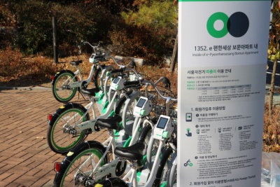
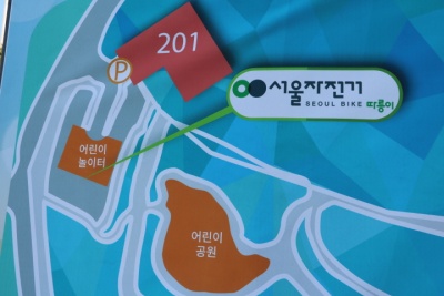
| | + | ===e 편한세상 보문아파트 내=== |
| | + | 서울특별시 성북구 낙산길 255 e 편한세상 보문아파트 내 |
| | + | {{ |
| | + | #display_map: |
| | + | 37.582376, 127.015600~ ~ ~ ~ ~e 편한세상 보문아파트 내 |
| | |service=googlemaps3 | | |service=googlemaps3 |
| | |width=300 | | |width=300 |
| 121번째 줄: |
301번째 줄: |
| | |zoom=12 | | |zoom=12 |
| | }} | | }} |
| − | [[파일:금호어울림센터힐_따릉이.jpg|400px]]http://www.sharehub.kr/sharestory/news_view.do?storySeq=161<br/ > | + | [[파일:보문아파트내.jpg|400px]][[파일:보문아파트내2.jpg|400px]]<br />http://www.sharehub.kr/sharestory/news_view.do?storySeq=160<br /> |
| − | *따릉이가 있는 101동 앞은 원래 자전거 거치대가 있었으나, 관리가 되지 못하여 고장 난 자전거, 주인 없는 자전거 등으로 골칫거리였는데 | + | *서울시 공공자전거 따릉이는 서울시민이 자주 사용하고 만족도가 높은 공유 정책 중 하나로 접근성을 높이기 위해 어린이 놀이터에 배치되었다. |
| − | 이곳을 서울시가 직접 관리하는 따릉이 거치대로 변경하여 미관 문제도 해결하고, 많은 사람이 이용할 수 있는 자전거를 확보할 수 있게 되었다.
| + | 따릉이거치대 옆에는 어린이 놀이터의 큰 정자가 있어 자전거 운행으로 힘들었던 몸을 잠시나마 쉬어갈 수도 있는 공간이 있어서 최적의 장소로 보인다. |
| | + | |
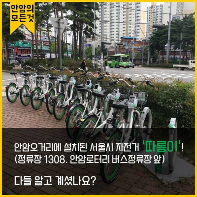
| | + | ===안암로터리 버스정류장 앞=== |
| | + | 서울특별시 성북구 안암로 69 안암로터리 버스정류장<br /> |
| | + | [[파일:안암로터리.jpg|400px]][https://www.facebook.com/AnamSASM/posts/%EC%8B%9C%ED%97%98%EB%8F%84-%EB%81%9D%EB%82%AC%EB%8A%94%EB%8D%B0-%EB%86%80%EB%9F%AC%EA%B0%80%EC%95%BC%EC%A7%80%EB%94%B0%EB%A6%89%EC%9D%B4-%ED%95%98%EB%82%98%EB%A9%B4-%EC%8A%88%ED%8D%BC%EC%B9%B4%EB%8F%84-%EC%95%88%EB%B6%80%EB%9F%AC%EC%9A%B4-%EA%B0%80%EC%9D%84-%EC%9E%90%EC%A0%84%EA%B1%B0-%EC%82%B0%EC%B1%85%EC%95%88%EC%95%94%EC%97%90%EC%84%9C-%EC%B6%9C%EB%B0%9C%ED%95%98%EB%8A%94-%EA%B3%A0%EB%8C%80%EC%83%9D-%EC%95%88%EC%84%B1%EB%A7%9E%EC%B6%A4-%EC%9E%90%EC%A0%84%EA%B1%B0-%EC%BD%94%EC%8A%A4%EC%9E%90%EC%A0%84%EA%B1%B0-%ED%83%80%EB%9F%AC-%EA%B0%80%EC%9E%90-%EC%B9%9C%EA%B5%AC-%ED%83%9C/1536852586395246/ 안암의 모든것] |
| | + | {{ |
| | + | #display_map: |
| | + | 37.582671, 127.028843~ ~ ~ ~ ~안암로터리 버스정류장 앞 |
| | + | |service=googlemaps3 |
| | + | |width=300 |
| | + | |height=300 |
| | + | |type=normal |
| | + | |overlays=videos-1,wikipedia |
| | + | |icon=http://maps.google.com/mapfiles/marker.png |
| | + | |zoom=12 |
| | + | }}<br /> |
| | + | |
| | + | ===정릉교회 앞=== |
| | + | 서울특별시 성북구 정릉로27가길 28-2 성북구 정릉동 138-15 |
| | + | {{ |
| | + | #display_map: |
| | + | 37.606785, 127.012695~ ~ ~ ~ ~정릉교회 앞 |
| | + | |service=googlemaps3 |
| | + | |width=300 |
| | + | |height=300 |
| | + | |type=normal |
| | + | |overlays=videos-1,wikipedia |
| | + | |icon=http://maps.google.com/mapfiles/marker.png |
| | + | |zoom=12 |
| | + | }}<br /> |
| | + | |
| | + | ===정릉꿈에그린1단지 201동 앞=== |
| | + | 서울특별시 성북구 아리랑로19길 20 성북구 정릉동 966-62 |
| | + | {{ |
| | + | #display_map: |
| | + | 37.602768, 127.012276~ ~ ~ ~ ~정릉꿈에그린1단지 201동 앞 |
| | + | |service=googlemaps3 |
| | + | |width=300 |
| | + | |height=300 |
| | + | |type=normal |
| | + | |overlays=videos-1,wikipedia |
| | + | |icon=http://maps.google.com/mapfiles/marker.png |
| | + | |zoom=12 |
| | + | }}<br /> |
| | + | |
| | + | ===고려사대부속중고 정문 및 건너편=== |
| | + | 서울특별시 성북구 보국문로29길 23 성북구 정릉동 966-1 |
| | + | {{ |
| | + | #display_map: |
| | + | 37.612404, 127.007715~ ~ ~ ~ ~고려사대부속중고 정문 및 건너편 |
| | + | |service=googlemaps3 |
| | + | |width=300 |
| | + | |height=300 |
| | + | |type=normal |
| | + | |overlays=videos-1,wikipedia |
| | + | |icon=http://maps.google.com/mapfiles/marker.png |
| | + | |zoom=12 |
| | + | }}<br /> |
| | + | |
| | + | ===정릉동 교통광장=== |
| | + | 서울특별시 성북구 솔샘로17길 8 정릉동 746-2 |
| | + | {{ |
| | + | #display_map: |
| | + | 37.613043, 127.005899~ ~ ~ ~ ~정릉동 교통광장 |
| | + | |service=googlemaps3 |
| | + | |width=300 |
| | + | |height=300 |
| | + | |type=normal |
| | + | |overlays=videos-1,wikipedia |
| | + | |icon=http://maps.google.com/mapfiles/marker.png |
| | + | |zoom=12 |
| | + | }}<br /> |
| | + | |
| | + | ===종암사거리 분수대=== |
| | + | 서울특별시 성북구 종암로 147 성북구 하월곡동 104-134 |
| | + | {{ |
| | + | #display_map: |
| | + | 37.603210, 127.031975~ ~ ~ ~ ~종암사거리 분수대 |
| | + | |service=googlemaps3 |
| | + | |width=300 |
| | + | |height=300 |
| | + | |type=normal |
| | + | |overlays=videos-1,wikipedia |
| | + | |icon=http://maps.google.com/mapfiles/marker.png |
| | + | |zoom=12 |
| | + | }}<br /> |
| | + | |
| | + | ===LG베스트샵 종암점=== |
| | + | 서울특별시 성북구 종암로 88 성북구 종암동 15-7 |
| | + | {{ |
| | + | #display_map: |
| | + | 37.598395, 127.035017~ ~ ~ ~ ~LG베스트샵 종암점 |
| | + | |service=googlemaps3 |
| | + | |width=300 |
| | + | |height=300 |
| | + | |type=normal |
| | + | |overlays=videos-1,wikipedia |
| | + | |icon=http://maps.google.com/mapfiles/marker.png |
| | + | |zoom=12 |
| | + | }}<br /> |
| | + | |
| | + | ===국민은행 종암동지점 앞=== |
| | + | 서울특별시 성북구 종암로3길 37-2 성북구 종암동 12-33 |
| | + | {{ |
| | + | #display_map: |
| | + | 37.593061, 127.033768~ ~ ~ ~ ~국민은행 종암동지점 앞 |
| | + | |service=googlemaps3 |
| | + | |width=300 |
| | + | |height=300 |
| | + | |type=normal |
| | + | |overlays=videos-1,wikipedia |
| | + | |icon=http://maps.google.com/mapfiles/marker.png |
| | + | |zoom=12 |
| | + | }}<br /> |
| | + | |
| | + | ===석관초등학교 앞=== |
| | + | 서울특별시 성북구 돌곶이로22길 21 성북구 석관동 202-3 |
| | + | {{ |
| | + | #display_map: |
| | + | 37.611087, 127.058753~ ~ ~ ~ ~석관초등학교 앞 |
| | + | |service=googlemaps3 |
| | + | |width=300 |
| | + | |height=300 |
| | + | |type=normal |
| | + | |overlays=videos-1,wikipedia |
| | + | |icon=http://maps.google.com/mapfiles/marker.png |
| | + | |zoom=12 |
| | + | }}<br /> |
| | + | |
| | + | ===석관동주민센터 앞=== |
| | + | 서울특별시 성북구 화랑로 296 성북구 석관동 384-2 |
| | + | {{ |
| | + | #display_map: |
| | + | 37.613198, 127.061417~ ~ ~ ~ ~석관동주민센터 앞 |
| | + | |service=googlemaps3 |
| | + | |width=300 |
| | + | |height=300 |
| | + | |type=normal |
| | + | |overlays=videos-1,wikipedia |
| | + | |icon=http://maps.google.com/mapfiles/marker.png |
| | + | |zoom=12 |
| | + | }}<br /> |
| | + | |
| | + | ===성북3교 위=== |
| | + | 서울특별시 성북구 보문로 192 성북3교 위 |
| | + | {{ |
| | + | #display_map: |
| | + | 37.591076, 127.014543~ ~ ~ ~ ~성북3교 위 |
| | + | |service=googlemaps3 |
| | + | |width=300 |
| | + | |height=300 |
| | + | |type=normal |
| | + | |overlays=videos-1,wikipedia |
| | + | |icon=http://maps.google.com/mapfiles/marker.png |
| | + | |zoom=12 |
| | + | }}<br /> |
| | + | |
| | + | ===돈암성당 옆=== |
| | + | 서울특별시 성북구 인촌로7길 120 돈암성당 옆 |
| | + | {{ |
| | + | #display_map: |
| | + | 37.590492, 127.017450~ ~ ~ ~ ~돈암성당 옆 |
| | + | |service=googlemaps3 |
| | + | |width=300 |
| | + | |height=300 |
| | + | |type=normal |
| | + | |overlays=videos-1,wikipedia |
| | + | |icon=http://maps.google.com/mapfiles/marker.png |
| | + | |zoom=12 |
| | + | }}<br /> |
| | + | |
| | + | ===용문2교 옆=== |
| | + | 서울특별시 성북구 인촌로7길 24 용문2교 옆 |
| | + | {{ |
| | + | #display_map: |
| | + | 37.587087, 127.020915~ ~ ~ ~ ~용문2교 옆 |
| | + | |service=googlemaps3 |
| | + | |width=300 |
| | + | |height=300 |
| | + | |type=normal |
| | + | |overlays=videos-1,wikipedia |
| | + | |icon=http://maps.google.com/mapfiles/marker.png |
| | + | |zoom=12 |
| | + | }}<br /> |
| | + | |
| | + | ===삼성전자서비스 성북센터=== |
| | + | 서울특별시 성북구 월계로 28 삼성전자서비스 성북센터 |
| | + | {{ |
| | + | #display_map: |
| | + | 37.610289, 127.033715~ ~ ~ ~ ~삼성전자서비스 성북센터 |
| | + | |service=googlemaps3 |
| | + | |width=300 |
| | + | |height=300 |
| | + | |type=normal |
| | + | |overlays=videos-1,wikipedia |
| | + | |icon=http://maps.google.com/mapfiles/marker.png |
| | + | |zoom=12 |
| | + | }}<br /> |
| | + | |
| | + | ===광운초등학교 앞=== |
| | + | 서울특별시 성북구 한천로 693 광운초등학교 앞 |
| | + | {{ |
| | + | #display_map: |
| | + | 37.618754, 127.054753~ ~ ~ ~ ~광운초등학교 앞 |
| | + | |service=googlemaps3 |
| | + | |width=300 |
| | + | |height=300 |
| | + | |type=normal |
| | + | |overlays=videos-1,wikipedia |
| | + | |icon=http://maps.google.com/mapfiles/marker.png |
| | + | |zoom=12 |
| | + | }}<br /> |
| | + | |
| | + | ===성북쉼터 앞=== |
| | + | 서울특별시 성북구 성북로21길 32 성북쉼터 앞 |
| | + | {{ |
| | + | #display_map: |
| | + | 37.592684, 126.997559~ ~ ~ ~ ~성북쉼터 앞 |
| | + | |service=googlemaps3 |
| | + | |width=300 |
| | + | |height=300 |
| | + | |type=normal |
| | + | |overlays=videos-1,wikipedia |
| | + | |icon=http://maps.google.com/mapfiles/marker.png |
| | + | |zoom=12 |
| | + | }}<br /> |
| | + | |
| | + | ===아리랑시네센터 앞=== |
| | + | 서울특별시 성북구 아리랑로 82 아리랑시네센터 앞 |
| | + | {{ |
| | + | #display_map: |
| | + | 37.600132, 127.013937~ ~ ~ ~ ~아리랑시네센터 앞 |
| | + | |service=googlemaps3 |
| | + | |width=300 |
| | + | |height=300 |
| | + | |type=normal |
| | + | |overlays=videos-1,wikipedia |
| | + | |icon=http://maps.google.com/mapfiles/marker.png |
| | + | |zoom=12 |
| | + | }}<br /> |
| | + | |
| | + | ===길음8골어린이공원 옆=== |
| | + | 서울특별시 성북구 길음로13길 22 길음8골어린이공원 옆 |
| | + | {{ |
| | + | #display_map: |
| | + | 37.609861, 127.018658~ ~ ~ ~ ~길음8골어린이공원 옆 |
| | + | |service=googlemaps3 |
| | + | |width=300 |
| | + | |height=300 |
| | + | |type=normal |
| | + | |overlays=videos-1,wikipedia |
| | + | |icon=http://maps.google.com/mapfiles/marker.png |
| | + | |zoom=12 |
| | + | }}<br /> |
| | + | |
| | + | ===길음래미안아파트817동 상가 앞=== |
| | + | 서울특별시 성북구 길음로 33 길음래미안아파트817동 상가 앞 |
| | + | {{ |
| | + | #display_map: |
| | + | 37.607800, 127.018052~ ~ ~ ~ ~길음래미안아파트817동 상가 앞 |
| | + | |service=googlemaps3 |
| | + | |width=300 |
| | + | |height=300 |
| | + | |type=normal |
| | + | |overlays=videos-1,wikipedia |
| | + | |icon=http://maps.google.com/mapfiles/marker.png |
| | + | |zoom=12 |
| | + | }}<br /> |
| | + | |
| | + | ===성북제일새마을금고 본점 앞=== |
| | + | 서울특별시 성북구 길음로 20 성북제일새마을금고 본점 앞 |
| | + | {{ |
| | + | #display_map: |
| | + | 37.604947, 127.023030~ ~ ~ ~ ~성북제일새마을금고 본점 앞 |
| | + | |service=googlemaps3 |
| | + | |width=300 |
| | + | |height=300 |
| | + | |type=normal |
| | + | |overlays=videos-1,wikipedia |
| | + | |icon=http://maps.google.com/mapfiles/marker.png |
| | + | |zoom=12 |
| | + | }}<br /> |
| | + | |
| | + | ===월계2교 버스정류장 앞=== |
| | + | 서울특별시 성북구 한천로101길 18 월계2교 버스정유장 앞 |
| | + | {{ |
| | + | #display_map: |
| | + | 37.623402, 127.049480~ ~ ~ ~ ~월계2교 버스정류장 앞 |
| | + | |service=googlemaps3 |
| | + | |width=300 |
| | + | |height=300 |
| | + | |type=normal |
| | + | |overlays=videos-1,wikipedia |
| | + | |icon=http://maps.google.com/mapfiles/marker.png |
| | + | |zoom=12 |
| | + | }}<br /> |
| | + | |
| | + | ===안암2교 옆=== |
| | + | 서울특별시 성북구 안암로 17 SK제삼주유소 앞 |
| | + | {{ |
| | + | #display_map: |
| | + | 37.579714, 127.024511~ ~ ~ ~ ~안암2교 옆 |
| | + | |service=googlemaps3 |
| | + | |width=300 |
| | + | |height=300 |
| | + | |type=normal |
| | + | |overlays=videos-1,wikipedia |
| | + | |icon=http://maps.google.com/mapfiles/marker.png |
| | + | |zoom=12 |
| | + | }}<br /> |
| | + | |
| | + | ===고려대학교 2번출구=== |
| | + | 서울특별시 성북구 종암로 지하 1 고려대학교 2번출구 |
| | + | {{ |
| | + | #display_map: |
| | + | 37.586367, 127.029704~ ~ ~ ~ ~고려대학교 2번출구 |
| | + | |service=googlemaps3 |
| | + | |width=300 |
| | + | |height=300 |
| | + | |type=normal |
| | + | |overlays=videos-1,wikipedia |
| | + | |icon=http://maps.google.com/mapfiles/marker.png |
| | + | |zoom=12 |
| | + | }}<br /> |
| | + | |
| | + | ===보문2교=== |
| | + | 서울특별시 성북구 보문로30길 29 보문2교 |
| | + | {{ |
| | + | #display_map: |
| | + | 37.589255, 127.018951~ ~ ~ ~ ~보문2교 |
| | + | |service=googlemaps3 |
| | + | |width=300 |
| | + | |height=300 |
| | + | |type=normal |
| | + | |overlays=videos-1,wikipedia |
| | + | |icon=http://maps.google.com/mapfiles/marker.png |
| | + | |zoom=12 |
| | + | }}<br /> |
| | + | |
| | + | ===정릉도서관 앞=== |
| | + | 서울특별시 성북구 보국문로 7-10 정릉도서관 앞 |
| | + | {{ |
| | + | #display_map: |
| | + | 37.612447, 127.007704~ ~ ~ ~ ~정릉도서관 앞 |
| | + | |service=googlemaps3 |
| | + | |width=300 |
| | + | |height=300 |
| | + | |type=normal |
| | + | |overlays=videos-1,wikipedia |
| | + | |icon=http://maps.google.com/mapfiles/marker.png |
| | + | |zoom=12 |
| | + | }}<br /> |
| | + | |
| | + | ===장위뉴타운 꿈에 숲 코오롱 하늘채 앞=== |
| | + | 서울특별시 성북구 월계로 172 장위뉴타운 꿈에 숲 코오롱 하늘채 앞 |
| | + | {{ |
| | + | #display_map: |
| | + | 37.619446, 127.044811~ ~ ~ ~ ~장위뉴타운 꿈에 숲 코오롱 하늘채 앞 |
| | + | |service=googlemaps3 |
| | + | |width=300 |
| | + | |height=300 |
| | + | |type=normal |
| | + | |overlays=videos-1,wikipedia |
| | + | |icon=http://maps.google.com/mapfiles/marker.png |
| | + | |zoom=12 |
| | + | }}<br /> |
| | + | |
| | + | ===홍익중고 입구=== |
| | + | 서울특별시 성북구 성북로14가길 23 홍익중고 입구 |
| | + | {{ |
| | + | #display_map: |
| | + | 37.594354, 127.003149~ ~ ~ ~ ~홍익중고 입구 |
| | + | |service=googlemaps3 |
| | + | |width=300 |
| | + | |height=300 |
| | + | |type=normal |
| | + | |overlays=videos-1,wikipedia |
| | + | |icon=http://maps.google.com/mapfiles/marker.png |
| | + | |zoom=12 |
| | + | }}<br /> |
| | + | |
| | + | ===보문4교 인근=== |
| | + | 서울특별시 성북구 보문로22길 28 보문4교 인근 |
| | + | {{ |
| | + | #display_map: |
| | + | 37.584051, 127.021948~ ~ ~ ~ ~보문4교 인근 |
| | + | |service=googlemaps3 |
| | + | |width=300 |
| | + | |height=300 |
| | + | |type=normal |
| | + | |overlays=videos-1,wikipedia |
| | + | |icon=http://maps.google.com/mapfiles/marker.png |
| | + | |zoom=12 |
| | + | }}<br /> |
| | + | |
| | + | ===성북동 치안센터 앞=== |
| | + | 서울특별시 성북구 성북로 25 성북동 치안센터 앞 |
| | + | {{ |
| | + | #display_map: |
| | + | 37.589221, 127.003883~ ~ ~ ~ ~성북동 치안센터 앞 |
| | + | |service=googlemaps3 |
| | + | |width=300 |
| | + | |height=300 |
| | + | |type=normal |
| | + | |overlays=videos-1,wikipedia |
| | + | |icon=http://maps.google.com/mapfiles/marker.png |
| | + | |zoom=12 |
| | + | }}<br /> |
| | + | |
| | + | ===선잠단지 앞=== |
| | + | 서울특별시 성북구 성북로 102-10 선잠단지 앞 |
| | + | {{ |
| | + | #display_map: |
| | + | 37.594025, 126.998418~ ~ ~ ~ ~선잠단지 앞 |
| | + | |service=googlemaps3 |
| | + | |width=300 |
| | + | |height=300 |
| | + | |type=normal |
| | + | |overlays=videos-1,wikipedia |
| | + | |icon=http://maps.google.com/mapfiles/marker.png |
| | + | |zoom=12 |
| | + | }}<br /> |
| | + | |
| | + | ===일신초등학교 옆=== |
| | + | 서울특별시 성북구 월곡로 74 일신초등학교 옆 |
| | + | {{ |
| | + | #display_map: |
| | + | 37.598613, 127.040307~ ~ ~ ~ ~일신초등학교 옆 |
| | + | |service=googlemaps3 |
| | + | |width=300 |
| | + | |height=300 |
| | + | |type=normal |
| | + | |overlays=videos-1,wikipedia |
| | + | |icon=http://maps.google.com/mapfiles/marker.png |
| | + | |zoom=12 |
| | + | }}<br /> |
| | + | |
| | + | ===길음문화복합미디어센터=== |
| | + | 서울특별시 성북구 길음로7길 20 길음문화복합미디어센터 |
| | + | {{ |
| | + | #display_map: |
| | + | 37.603938, 127.022596~ ~ ~ ~ ~길음문화복합미디어센터 |
| | + | |service=googlemaps3 |
| | + | |width=300 |
| | + | |height=300 |
| | + | |type=normal |
| | + | |overlays=videos-1,wikipedia |
| | + | |icon=http://maps.google.com/mapfiles/marker.png |
| | + | |zoom=12 |
| | + | }}<br /> |
| | + | |
| | + | ===성신여대입구 교차로=== |
| | + | 서울특별시 성북구 보문로34길 87 성신여대입구 교차로 |
| | + | {{ |
| | + | #display_map: |
| | + | 37.591693, 127.020108~ ~ ~ ~ ~성신여대입구 교차로 |
| | + | |service=googlemaps3 |
| | + | |width=300 |
| | + | |height=300 |
| | + | |type=normal |
| | + | |overlays=videos-1,wikipedia |
| | + | |icon=http://maps.google.com/mapfiles/marker.png |
| | + | |zoom=12 |
| | + | }}<br /> |
| | + | |
| | + | ===미아사거리=== |
| | + | 서울특별시 성북구 동소문로 327 미아사거리 |
| | + | {{ |
| | + | #display_map: |
| | + | 37.609318, 127.029743~ ~ ~ ~ ~미아사거리 |
| | + | |service=googlemaps3 |
| | + | |width=300 |
| | + | |height=300 |
| | + | |type=normal |
| | + | |overlays=videos-1,wikipedia |
| | + | |icon=http://maps.google.com/mapfiles/marker.png |
| | + | |zoom=12 |
| | + | }}<br /> |
| | + | |
| | + | ===복자사랑 피정의 집=== |
| | + | 서울특별시 성북구 성북로 132-4 복자사랑 피정의 집 |
| | + | {{ |
| | + | #display_map: |
| | + | 37.594463, 126.995478~ ~ ~ ~ ~복자사랑 피정의 집 |
| | + | |service=googlemaps3 |
| | + | |width=300 |
| | + | |height=300 |
| | + | |type=normal |
| | + | |overlays=videos-1,wikipedia |
| | + | |icon=http://maps.google.com/mapfiles/marker.png |
| | + | |zoom=12 |
| | + | }}<br /> |
| | + | |
| | + | ===KEB은행 고대점=== |
| | + | 서울특별시 성북구 인촌로 113 KEB은행 고대점 |
| | + | {{ |
| | + | #display_map: |
| | + | 37.586833, 127.031898~ ~ ~ ~ ~KEB은행 고대점 |
| | + | |service=googlemaps3 |
| | + | |width=300 |
| | + | |height=300 |
| | + | |type=normal |
| | + | |overlays=videos-1,wikipedia |
| | + | |icon=http://maps.google.com/mapfiles/marker.png |
| | + | |zoom=12 |
| | + | }}<br /> |
| | + | |
| | + | ===성북구보건소 건너편=== |
| | + | 서울특별시 성북구 화랑로 63 성북구보건소 건너편 |
| | + | {{ |
| | + | #display_map: |
| | + | 37.602945, 127.039471~ ~ ~ ~ ~성북구보건소 건너편 |
| | + | |service=googlemaps3 |
| | + | |width=300 |
| | + | |height=300 |
| | + | |type=normal |
| | + | |overlays=videos-1,wikipedia |
| | + | |icon=http://maps.google.com/mapfiles/marker.png |
| | + | |zoom=12 |
| | + | }}<br /> |
| | | | |
| | ==주의사항== | | ==주의사항== |
| | + | '''따릉이 안전수칙'''<br /> |
| | + | [[파일:따릉이의 안전수칙.jpg|400px]]http://hongemama.tistory.com/26<br /><br /> |
| | + | <youtube>sSSoJgNeIXo</youtube> |
| | + | |
| | + | ==출처== |
| | + | [https://terms.naver.com/entry.nhn?docId=5678862&cid=43667&categoryId=43667/ 네이버 백과사전] |
| | + | [https://www.google.co.kr/maps/@45.2000678,17.2800773,5z?hl=ko/ 구글 맵] |
| | + | [https://www.bikeseoul.com/ 서울자전거 따릉이 공식 웹페이지]<br /><br /> |
| | + | [[파일:CCBY.png]] |
| | + | https://creativecommons.org/about/downloads |
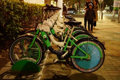
 따릉이 공식웹페이지
https://www.flickr.com/photos/142036864@N07/33089668054/in/photolist-21UBJU6-Sq2cub-29qHgod-zVhhu1-yMmF2V-zrBBnQ-yS9NK4-zFVPjb-zrBAWQ-zFVMFb-zrJ5NZ-zH8v75-28b6LPE-293R3tQ-PnkPY2-Nm646t-2d2c6hh-29NAUbX-2bQfavf
따릉이란?
- 서울시가 운영하는 자전거 무인 대여 시스템으로, 2015년 10월 직장인들의 출·퇴근 시 이용을 도와 자전거 교통 분담률을 높이고 친환경 자전거 도시를 만든다는 일환으로 실시됐다.
- 지하철 출입구·버스정류장·관공서·학교 등 접근이 쉬운 통행 장소 등에 대여소가 설치되어있으며, 대여소에서 따릉이의 대여와 반납이 무인으로 이뤄지며, 이용자들이 장소에 구애받지 않고 대여소가 설치된 곳이면 어디에서나 자전거를 대여하고 반납할 수 있다는 점이 특징이다.
이용방법
https://opengov.seoul.go.kr/seoullove/10248214
이용권 가격
7일권 일반(1시간) 3000원, 프리미엄(2시간) 4000원

30일권 일반(1시간) 5000원, 프리미엄(2시간) 7000원

180일권 일반(1시간) 15000원, 프리미엄(2시간) 20000원

365일권 일반(1시간) 30000원, 프리미엄(2시간) 40000원
일일권은 일반(1시간) 1000원, 프리미엄(2시간) 2000원이다. 이용시간은 이용권 해당 시간에 따라 적용되고 이용시간 초과시 20분당 500원의 추가 요금이 부과된다.
대여
어플 설치 후 1.회원가입 2.이용권구매 3.지도에서 대여소 선택 4.대여요청 5.단말기 홈버튼 선택
어플 설치 후 1.비회원 선택 2.따릉이 홈버튼 누르기 3.대여번호 입력 선택 4.대여번호 8자리 중 앞 4자리 입력 5.대여번호 8자리 중 뒤 4자리 입력
반납
거치대 반납

1.반납할 대여소에 방문

2.빈 거치대에 자전거를 거치함

3.거치대의 잠금 장치를 자전거 단말기 우측에 연결하여 자전거를 잠금

4.자전거 단말기에서 “반납 완료”안내가 나오면 반납이 완료된 것 (반납 완료는 SMS로도 발송됨)
연결 반납
성북구 역근처 대여소 위치
한성대입구역 2번출구'
서울특별시 성북구 동소문로 2 성북구 동소문동2가 2-3
지도를 불러오는 중...
{"minzoom":false,"maxzoom":false,"mappingservice":"googlemaps3","type":"ROADMAP","types":["ROADMAP","SATELLITE","HYBRID","TERRAIN"],"width":"300px","height":"300px","centre":false,"title":"","label":"","icon":"http://maps.google.com/mapfiles/marker.png","visitedicon":"","lines":[],"polygons":[],"circles":[],"rectangles":[],"wmsoverlay":false,"copycoords":false,"static":false,"zoom":12,"layers":[],"controls":["pan","zoom","type","scale","streetview"],"zoomstyle":"DEFAULT","typestyle":"DEFAULT","autoinfowindows":false,"resizable":false,"kmlrezoom":false,"poi":true,"markercluster":false,"clustergridsize":60,"clustermaxzoom":20,"clusterzoomonclick":true,"clusteraveragecenter":true,"clusterminsize":2,"tilt":0,"imageoverlays":[],"kml":[],"gkml":[],"fusiontables":[],"searchmarkers":"","enablefullscreen":false,"locations":[{"text":"\u003Cb\u003E\u003Cdiv class=\"mw-parser-output\"\u003E\u003C/div\u003E\u003C/b\u003E\u003Chr /\u003E\u003Cdiv class=\"mw-parser-output\"\u003E\u003C/div\u003E","title":"","link":"","lat":37.588412,"lon":127.006679,"icon":"http://maps.google.com/mapfiles/marker.png","inlineLabel":"\ud55c\uc131\ub300\uc785\uad6c\uc5ed 2\ubc88\ucd9c\uad6c\n"}]}
한성대입구역 6번출구 뒤
서울특별시 성북구 동소문로 1 한성대입구역 6번출구 뒤
지도를 불러오는 중...
{"minzoom":false,"maxzoom":false,"mappingservice":"googlemaps3","type":"ROADMAP","types":["ROADMAP","SATELLITE","HYBRID","TERRAIN"],"width":"300px","height":"300px","centre":false,"title":"","label":"","icon":"http://maps.google.com/mapfiles/marker.png","visitedicon":"","lines":[],"polygons":[],"circles":[],"rectangles":[],"wmsoverlay":false,"copycoords":false,"static":false,"zoom":12,"layers":[],"controls":["pan","zoom","type","scale","streetview"],"zoomstyle":"DEFAULT","typestyle":"DEFAULT","autoinfowindows":false,"resizable":false,"kmlrezoom":false,"poi":true,"markercluster":false,"clustergridsize":60,"clustermaxzoom":20,"clusterzoomonclick":true,"clusteraveragecenter":true,"clusterminsize":2,"tilt":0,"imageoverlays":[],"kml":[],"gkml":[],"fusiontables":[],"searchmarkers":"","enablefullscreen":false,"locations":[{"text":"\u003Cb\u003E\u003Cdiv class=\"mw-parser-output\"\u003E\u003C/div\u003E\u003C/b\u003E\u003Chr /\u003E\u003Cdiv class=\"mw-parser-output\"\u003E\u003C/div\u003E","title":"","link":"","lat":37.588727,"lon":127.006181,"icon":"http://maps.google.com/mapfiles/marker.png","inlineLabel":"\ud55c\uc131\ub300\uc785\uad6c\uc5ed 6\ubc88\ucd9c\uad6c \ub4a4\n"}]}
한성대입구 7번출구 앞
서울특별시 성북구 동소문로 11 한성대7번출구 앞
지도를 불러오는 중...
{"minzoom":false,"maxzoom":false,"mappingservice":"googlemaps3","type":"ROADMAP","types":["ROADMAP","SATELLITE","HYBRID","TERRAIN"],"width":"300px","height":"300px","centre":false,"title":"","label":"","icon":"http://maps.google.com/mapfiles/marker.png","visitedicon":"","lines":[],"polygons":[],"circles":[],"rectangles":[],"wmsoverlay":false,"copycoords":false,"static":false,"zoom":12,"layers":[],"controls":["pan","zoom","type","scale","streetview"],"zoomstyle":"DEFAULT","typestyle":"DEFAULT","autoinfowindows":false,"resizable":false,"kmlrezoom":false,"poi":true,"markercluster":false,"clustergridsize":60,"clustermaxzoom":20,"clusterzoomonclick":true,"clusteraveragecenter":true,"clusterminsize":2,"tilt":0,"imageoverlays":[],"kml":[],"gkml":[],"fusiontables":[],"searchmarkers":"","enablefullscreen":false,"locations":[{"text":"\u003Cb\u003E\u003Cdiv class=\"mw-parser-output\"\u003E\u003C/div\u003E\u003C/b\u003E\u003Chr /\u003E\u003Cdiv class=\"mw-parser-output\"\u003E\u003C/div\u003E","title":"","link":"","lat":37.588865,"lon":127.006774,"icon":"http://maps.google.com/mapfiles/marker.png","inlineLabel":"\ud55c\uc131\ub300\uc785\uad6c\uc5ed 7\ubc88\ucd9c\uad6c \uc55e\n"}]}
월곡역 3번출구
서울특별시 성북구 월곡로 지하 107 성북구 하월곡동 37-4
지도를 불러오는 중...
{"minzoom":false,"maxzoom":false,"mappingservice":"googlemaps3","type":"ROADMAP","types":["ROADMAP","SATELLITE","HYBRID","TERRAIN"],"width":"300px","height":"300px","centre":false,"title":"","label":"","icon":"http://maps.google.com/mapfiles/marker.png","visitedicon":"","lines":[],"polygons":[],"circles":[],"rectangles":[],"wmsoverlay":false,"copycoords":false,"static":false,"zoom":12,"layers":[],"controls":["pan","zoom","type","scale","streetview"],"zoomstyle":"DEFAULT","typestyle":"DEFAULT","autoinfowindows":false,"resizable":false,"kmlrezoom":false,"poi":true,"markercluster":false,"clustergridsize":60,"clustermaxzoom":20,"clusterzoomonclick":true,"clusteraveragecenter":true,"clusterminsize":2,"tilt":0,"imageoverlays":[],"kml":[],"gkml":[],"fusiontables":[],"searchmarkers":"","enablefullscreen":false,"locations":[{"text":"\u003Cb\u003E\u003Cdiv class=\"mw-parser-output\"\u003E\u003C/div\u003E\u003C/b\u003E\u003Chr /\u003E\u003Cdiv class=\"mw-parser-output\"\u003E\u003C/div\u003E","title":"","link":"","lat":37.602538,"lon":127.041593,"icon":"http://maps.google.com/mapfiles/marker.png","inlineLabel":"\uc6d4\uace1\uc5ed 3\ubc88\ucd9c\uad6c\n"}]}
월곡역 입구 육교 밑
서울특별시 성북구 월곡로 지하 107 성북구 종암동 113-10
지도를 불러오는 중...
{"minzoom":false,"maxzoom":false,"mappingservice":"googlemaps3","type":"ROADMAP","types":["ROADMAP","SATELLITE","HYBRID","TERRAIN"],"width":"300px","height":"300px","centre":false,"title":"","label":"","icon":"http://maps.google.com/mapfiles/marker.png","visitedicon":"","lines":[],"polygons":[],"circles":[],"rectangles":[],"wmsoverlay":false,"copycoords":false,"static":false,"zoom":12,"layers":[],"controls":["pan","zoom","type","scale","streetview"],"zoomstyle":"DEFAULT","typestyle":"DEFAULT","autoinfowindows":false,"resizable":false,"kmlrezoom":false,"poi":true,"markercluster":false,"clustergridsize":60,"clustermaxzoom":20,"clusterzoomonclick":true,"clusteraveragecenter":true,"clusterminsize":2,"tilt":0,"imageoverlays":[],"kml":[],"gkml":[],"fusiontables":[],"searchmarkers":"","enablefullscreen":false,"locations":[{"text":"\u003Cb\u003E\u003Cdiv class=\"mw-parser-output\"\u003E\u003C/div\u003E\u003C/b\u003E\u003Chr /\u003E\u003Cdiv class=\"mw-parser-output\"\u003E\u003C/div\u003E","title":"","link":"","lat":37.601406,"lon":127.041304,"icon":"http://maps.google.com/mapfiles/marker.png","inlineLabel":"\uc6d4\uace1\uc5ed \uc785\uad6c \uc721\uad50 \ubc11\n"}]}
길음역 3번출구 뒤
서울특별시 성북구 동소문로 248 동소문로248
지도를 불러오는 중...
{"minzoom":false,"maxzoom":false,"mappingservice":"googlemaps3","type":"ROADMAP","types":["ROADMAP","SATELLITE","HYBRID","TERRAIN"],"width":"300px","height":"300px","centre":false,"title":"","label":"","icon":"http://maps.google.com/mapfiles/marker.png","visitedicon":"","lines":[],"polygons":[],"circles":[],"rectangles":[],"wmsoverlay":false,"copycoords":false,"static":false,"zoom":12,"layers":[],"controls":["pan","zoom","type","scale","streetview"],"zoomstyle":"DEFAULT","typestyle":"DEFAULT","autoinfowindows":false,"resizable":false,"kmlrezoom":false,"poi":true,"markercluster":false,"clustergridsize":60,"clustermaxzoom":20,"clusterzoomonclick":true,"clusteraveragecenter":true,"clusterminsize":2,"tilt":0,"imageoverlays":[],"kml":[],"gkml":[],"fusiontables":[],"searchmarkers":"","enablefullscreen":false,"locations":[{"text":"\u003Cb\u003E\u003Cdiv class=\"mw-parser-output\"\u003E\u003C/div\u003E\u003C/b\u003E\u003Chr /\u003E\u003Cdiv class=\"mw-parser-output\"\u003E\u003C/div\u003E","title":"","link":"","lat":37.602703,"lon":127.024517,"icon":"http://maps.google.com/mapfiles/marker.png","inlineLabel":"\uae38\uc74c\uc5ed 3\ubc88\ucd9c\uad6c \ub4a4\n"}]}
상월곡역 4번출구
서울특별시 성북구 화랑로 148 성북구 상월곡동 산7-1
지도를 불러오는 중...
{"minzoom":false,"maxzoom":false,"mappingservice":"googlemaps3","type":"ROADMAP","types":["ROADMAP","SATELLITE","HYBRID","TERRAIN"],"width":"300px","height":"300px","centre":false,"title":"","label":"","icon":"http://maps.google.com/mapfiles/marker.png","visitedicon":"","lines":[],"polygons":[],"circles":[],"rectangles":[],"wmsoverlay":false,"copycoords":false,"static":false,"zoom":12,"layers":[],"controls":["pan","zoom","type","scale","streetview"],"zoomstyle":"DEFAULT","typestyle":"DEFAULT","autoinfowindows":false,"resizable":false,"kmlrezoom":false,"poi":true,"markercluster":false,"clustergridsize":60,"clustermaxzoom":20,"clusterzoomonclick":true,"clusteraveragecenter":true,"clusterminsize":2,"tilt":0,"imageoverlays":[],"kml":[],"gkml":[],"fusiontables":[],"searchmarkers":"","enablefullscreen":false,"locations":[{"text":"\u003Cb\u003E\u003Cdiv class=\"mw-parser-output\"\u003E\u003C/div\u003E\u003C/b\u003E\u003Chr /\u003E\u003Cdiv class=\"mw-parser-output\"\u003E\u003C/div\u003E","title":"","link":"","lat":37.605531,"lon":127.047268,"icon":"http://maps.google.com/mapfiles/marker.png","inlineLabel":"\uc0c1\uc6d4\uace1\uc5ed 4\ubc88\ucd9c\uad6c\n"}]}
상월곡역 1번출구
서울특별시 성북구 화랑로 지하 157 성북구 상월곡동 35-9
지도를 불러오는 중...
{"minzoom":false,"maxzoom":false,"mappingservice":"googlemaps3","type":"ROADMAP","types":["ROADMAP","SATELLITE","HYBRID","TERRAIN"],"width":"300px","height":"300px","centre":false,"title":"","label":"","icon":"http://maps.google.com/mapfiles/marker.png","visitedicon":"","lines":[],"polygons":[],"circles":[],"rectangles":[],"wmsoverlay":false,"copycoords":false,"static":false,"zoom":12,"layers":[],"controls":["pan","zoom","type","scale","streetview"],"zoomstyle":"DEFAULT","typestyle":"DEFAULT","autoinfowindows":false,"resizable":false,"kmlrezoom":false,"poi":true,"markercluster":false,"clustergridsize":60,"clustermaxzoom":20,"clusterzoomonclick":true,"clusteraveragecenter":true,"clusterminsize":2,"tilt":0,"imageoverlays":[],"kml":[],"gkml":[],"fusiontables":[],"searchmarkers":"","enablefullscreen":false,"locations":[{"text":"\u003Cb\u003E\u003Cdiv class=\"mw-parser-output\"\u003E\u003C/div\u003E\u003C/b\u003E\u003Chr /\u003E\u003Cdiv class=\"mw-parser-output\"\u003E\u003C/div\u003E","title":"","link":"","lat":37.605905,"lon":127.047134,"icon":"http://maps.google.com/mapfiles/marker.png","inlineLabel":"\uc0c1\uc6d4\uace1\uc5ed 1\ubc88\ucd9c\uad6c\n"}]}
상월곡역 3번출구
서울특별시 성북구 화랑로 지하 157 성북구 상월곡동 26-1
지도를 불러오는 중...
{"minzoom":false,"maxzoom":false,"mappingservice":"googlemaps3","type":"ROADMAP","types":["ROADMAP","SATELLITE","HYBRID","TERRAIN"],"width":"300px","height":"300px","centre":false,"title":"","label":"","icon":"http://maps.google.com/mapfiles/marker.png","visitedicon":"","lines":[],"polygons":[],"circles":[],"rectangles":[],"wmsoverlay":false,"copycoords":false,"static":false,"zoom":12,"layers":[],"controls":["pan","zoom","type","scale","streetview"],"zoomstyle":"DEFAULT","typestyle":"DEFAULT","autoinfowindows":false,"resizable":false,"kmlrezoom":false,"poi":true,"markercluster":false,"clustergridsize":60,"clustermaxzoom":20,"clusterzoomonclick":true,"clusteraveragecenter":true,"clusterminsize":2,"tilt":0,"imageoverlays":[],"kml":[],"gkml":[],"fusiontables":[],"searchmarkers":"","enablefullscreen":false,"locations":[{"text":"\u003Cb\u003E\u003Cdiv class=\"mw-parser-output\"\u003E\u003C/div\u003E\u003C/b\u003E\u003Chr /\u003E\u003Cdiv class=\"mw-parser-output\"\u003E\u003C/div\u003E","title":"","link":"","lat":37.60728,"lon":127.050567,"icon":"http://maps.google.com/mapfiles/marker.png","inlineLabel":"\uc0c1\uc6d4\uace1\uc5ed 3\ubc88\ucd9c\uad6c\n"}]}
석계역 5번출구 건너편
서울특별시 노원구 화랑로 지하 347-1 성북구 석관동 134-4
지도를 불러오는 중...
{"minzoom":false,"maxzoom":false,"mappingservice":"googlemaps3","type":"ROADMAP","types":["ROADMAP","SATELLITE","HYBRID","TERRAIN"],"width":"300px","height":"300px","centre":false,"title":"","label":"","icon":"http://maps.google.com/mapfiles/marker.png","visitedicon":"","lines":[],"polygons":[],"circles":[],"rectangles":[],"wmsoverlay":false,"copycoords":false,"static":false,"zoom":12,"layers":[],"controls":["pan","zoom","type","scale","streetview"],"zoomstyle":"DEFAULT","typestyle":"DEFAULT","autoinfowindows":false,"resizable":false,"kmlrezoom":false,"poi":true,"markercluster":false,"clustergridsize":60,"clustermaxzoom":20,"clusterzoomonclick":true,"clusteraveragecenter":true,"clusterminsize":2,"tilt":0,"imageoverlays":[],"kml":[],"gkml":[],"fusiontables":[],"searchmarkers":"","enablefullscreen":false,"locations":[{"text":"\u003Cb\u003E\u003Cdiv class=\"mw-parser-output\"\u003E\u003C/div\u003E\u003C/b\u003E\u003Chr /\u003E\u003Cdiv class=\"mw-parser-output\"\u003E\u003C/div\u003E","title":"","link":"","lat":37.613583,"lon":127.065773,"icon":"http://maps.google.com/mapfiles/marker.png","inlineLabel":"\uc11d\uacc4\uc5ed 5\ubc88\ucd9c\uad6c \uac74\ub108\ud3b8\n"}]}
북한산보국문역
서울특별시 성북구 보국문로 91 북한산보국문역
지도를 불러오는 중...
{"minzoom":false,"maxzoom":false,"mappingservice":"googlemaps3","type":"ROADMAP","types":["ROADMAP","SATELLITE","HYBRID","TERRAIN"],"width":"300px","height":"300px","centre":false,"title":"","label":"","icon":"http://maps.google.com/mapfiles/marker.png","visitedicon":"","lines":[],"polygons":[],"circles":[],"rectangles":[],"wmsoverlay":false,"copycoords":false,"static":false,"zoom":12,"layers":[],"controls":["pan","zoom","type","scale","streetview"],"zoomstyle":"DEFAULT","typestyle":"DEFAULT","autoinfowindows":false,"resizable":false,"kmlrezoom":false,"poi":true,"markercluster":false,"clustergridsize":60,"clustermaxzoom":20,"clusterzoomonclick":true,"clusteraveragecenter":true,"clusterminsize":2,"tilt":0,"imageoverlays":[],"kml":[],"gkml":[],"fusiontables":[],"searchmarkers":"","enablefullscreen":false,"locations":[{"text":"\u003Cb\u003E\u003Cdiv class=\"mw-parser-output\"\u003E\u003C/div\u003E\u003C/b\u003E\u003Chr /\u003E\u003Cdiv class=\"mw-parser-output\"\u003E\u003C/div\u003E","title":"","link":"","lat":37.612555,"lon":127.007741,"icon":"http://maps.google.com/mapfiles/marker.png","inlineLabel":"\ubd81\ud55c\uc0b0\ubcf4\uad6d\ubb38\uc5ed\n"}]}
정릉역
서울특별시 성북구 정릉로 272 정릉역
지도를 불러오는 중...
{"minzoom":false,"maxzoom":false,"mappingservice":"googlemaps3","type":"ROADMAP","types":["ROADMAP","SATELLITE","HYBRID","TERRAIN"],"width":"300px","height":"300px","centre":false,"title":"","label":"","icon":"http://maps.google.com/mapfiles/marker.png","visitedicon":"","lines":[],"polygons":[],"circles":[],"rectangles":[],"wmsoverlay":false,"copycoords":false,"static":false,"zoom":12,"layers":[],"controls":["pan","zoom","type","scale","streetview"],"zoomstyle":"DEFAULT","typestyle":"DEFAULT","autoinfowindows":false,"resizable":false,"kmlrezoom":false,"poi":true,"markercluster":false,"clustergridsize":60,"clustermaxzoom":20,"clusterzoomonclick":true,"clusteraveragecenter":true,"clusterminsize":2,"tilt":0,"imageoverlays":[],"kml":[],"gkml":[],"fusiontables":[],"searchmarkers":"","enablefullscreen":false,"locations":[{"text":"\u003Cb\u003E\u003Cdiv class=\"mw-parser-output\"\u003E\u003C/div\u003E\u003C/b\u003E\u003Chr /\u003E\u003Cdiv class=\"mw-parser-output\"\u003E\u003C/div\u003E","title":"","link":"","lat":37.603191,"lon":127.013603,"icon":"http://maps.google.com/mapfiles/marker.png","inlineLabel":"\uc815\ub989\uc5ed\n"}]}
보문역6번출구 앞
서울특별시 성북구 보문로 112-2 보문역6번출구 앞
지도를 불러오는 중...
{"minzoom":false,"maxzoom":false,"mappingservice":"googlemaps3","type":"ROADMAP","types":["ROADMAP","SATELLITE","HYBRID","TERRAIN"],"width":"300px","height":"300px","centre":false,"title":"","label":"","icon":"http://maps.google.com/mapfiles/marker.png","visitedicon":"","lines":[],"polygons":[],"circles":[],"rectangles":[],"wmsoverlay":false,"copycoords":false,"static":false,"zoom":12,"layers":[],"controls":["pan","zoom","type","scale","streetview"],"zoomstyle":"DEFAULT","typestyle":"DEFAULT","autoinfowindows":false,"resizable":false,"kmlrezoom":false,"poi":true,"markercluster":false,"clustergridsize":60,"clustermaxzoom":20,"clusterzoomonclick":true,"clusteraveragecenter":true,"clusterminsize":2,"tilt":0,"imageoverlays":[],"kml":[],"gkml":[],"fusiontables":[],"searchmarkers":"","enablefullscreen":false,"locations":[{"text":"\u003Cb\u003E\u003Cdiv class=\"mw-parser-output\"\u003E\u003C/div\u003E\u003C/b\u003E\u003Chr /\u003E\u003Cdiv class=\"mw-parser-output\"\u003E\u003C/div\u003E","title":"","link":"","lat":37.585004,"lon":127.019658,"icon":"http://maps.google.com/mapfiles/marker.png","inlineLabel":"\ubcf4\ubb38\uc5ed6\ubc88\ucd9c\uad6c \uc55e\n"}]}
성북구 그 외 대여소 위치
금호어울림센터힐 내
서울특별시 성북구 동소문로34길 73 금호어울림센터힐 내
지도를 불러오는 중...
{"minzoom":false,"maxzoom":false,"mappingservice":"googlemaps3","type":"ROADMAP","types":["ROADMAP","SATELLITE","HYBRID","TERRAIN"],"width":"300px","height":"300px","centre":false,"title":"","label":"","icon":"http://maps.google.com/mapfiles/marker.png","visitedicon":"","lines":[],"polygons":[],"circles":[],"rectangles":[],"wmsoverlay":false,"copycoords":false,"static":false,"zoom":12,"layers":[],"controls":["pan","zoom","type","scale","streetview"],"zoomstyle":"DEFAULT","typestyle":"DEFAULT","autoinfowindows":false,"resizable":false,"kmlrezoom":false,"poi":true,"markercluster":false,"clustergridsize":60,"clustermaxzoom":20,"clusterzoomonclick":true,"clusteraveragecenter":true,"clusterminsize":2,"tilt":0,"imageoverlays":[],"kml":[],"gkml":[],"fusiontables":[],"searchmarkers":"","enablefullscreen":false,"locations":[{"text":"\u003Cb\u003E\u003Cdiv class=\"mw-parser-output\"\u003E\u003C/div\u003E\u003C/b\u003E\u003Chr /\u003E\u003Cdiv class=\"mw-parser-output\"\u003E\u003C/div\u003E","title":"","link":"","lat":37.60076,"lon":127.024234,"icon":"http://maps.google.com/mapfiles/marker.png","inlineLabel":"\uae08\ud638\uc5b4\uc6b8\ub9bc\uc13c\ud130\ud790 \ub0b4\n"}]}
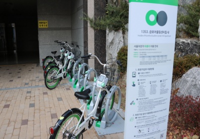 http://www.sharehub.kr/sharestory/news_view.do?storySeq=161
*따릉이가 있는 101동 앞은 원래 자전거 거치대가 있었으나, 관리가 되지 못하여 고장 난 자전거, 주인 없는 자전거 등으로 골칫거리였는데
이곳을 서울시가 직접 관리하는 따릉이 거치대로 변경하여 미관 문제도 해결하고, 많은 사람이 이용할 수 있는 자전거를 확보할 수 있게 되었다.
돈암초교 입구
서울특별시 성북구 동소문로13길 38 돈암초교
지도를 불러오는 중...
{"minzoom":false,"maxzoom":false,"mappingservice":"googlemaps3","type":"ROADMAP","types":["ROADMAP","SATELLITE","HYBRID","TERRAIN"],"width":"300px","height":"300px","centre":false,"title":"","label":"","icon":"http://maps.google.com/mapfiles/marker.png","visitedicon":"","lines":[],"polygons":[],"circles":[],"rectangles":[],"wmsoverlay":false,"copycoords":false,"static":false,"zoom":12,"layers":[],"controls":["pan","zoom","type","scale","streetview"],"zoomstyle":"DEFAULT","typestyle":"DEFAULT","autoinfowindows":false,"resizable":false,"kmlrezoom":false,"poi":true,"markercluster":false,"clustergridsize":60,"clustermaxzoom":20,"clusterzoomonclick":true,"clusteraveragecenter":true,"clusterminsize":2,"tilt":0,"imageoverlays":[],"kml":[],"gkml":[],"fusiontables":[],"searchmarkers":"","enablefullscreen":false,"locations":[{"text":"\u003Cb\u003E\u003Cdiv class=\"mw-parser-output\"\u003E\u003C/div\u003E\u003C/b\u003E\u003Chr /\u003E\u003Cdiv class=\"mw-parser-output\"\u003E\u003C/div\u003E","title":"","link":"","lat":37.593635,"lon":127.013093,"icon":"http://maps.google.com/mapfiles/marker.png","inlineLabel":"\ub3c8\uc554\ucd08\uad50 \uc785\uad6c\n"}]}
만해공원
서울특별시 성북구 성북로 132-1 만해공원
지도를 불러오는 중...
{"minzoom":false,"maxzoom":false,"mappingservice":"googlemaps3","type":"ROADMAP","types":["ROADMAP","SATELLITE","HYBRID","TERRAIN"],"width":"300px","height":"300px","centre":false,"title":"","label":"","icon":"http://maps.google.com/mapfiles/marker.png","visitedicon":"","lines":[],"polygons":[],"circles":[],"rectangles":[],"wmsoverlay":false,"copycoords":false,"static":false,"zoom":12,"layers":[],"controls":["pan","zoom","type","scale","streetview"],"zoomstyle":"DEFAULT","typestyle":"DEFAULT","autoinfowindows":false,"resizable":false,"kmlrezoom":false,"poi":true,"markercluster":false,"clustergridsize":60,"clustermaxzoom":20,"clusterzoomonclick":true,"clusteraveragecenter":true,"clusterminsize":2,"tilt":0,"imageoverlays":[],"kml":[],"gkml":[],"fusiontables":[],"searchmarkers":"","enablefullscreen":false,"locations":[{"text":"\u003Cb\u003E\u003Cdiv class=\"mw-parser-output\"\u003E\u003C/div\u003E\u003C/b\u003E\u003Chr /\u003E\u003Cdiv class=\"mw-parser-output\"\u003E\u003C/div\u003E","title":"","link":"","lat":37.594792,"lon":126.994995,"icon":"http://maps.google.com/mapfiles/marker.png","inlineLabel":"\ub9cc\ud574\uacf5\uc6d0\n"}]}
만해산책공원 입구
 http://seoulstory.kr/front/kor/story/view.dosearchCondition=&searchKeyword=&sStatus=9&sDivi=0&sTag=%EB%A7%88%EC%A0%80%EC%A0%88%EC%9C%84&pageIndex=1&idx=5419
 http://blog.naver.com/PostView.nhn?blogId=imkyo052&logNo=221281656517&categoryNo=72&parentCategoryNo=21&viewDate=¤tPage=1&postListTopCurrentPage=1&from=postView
성북구청
서울특별시 성북구 보문로 168 성북구청
지도를 불러오는 중...
{"minzoom":false,"maxzoom":false,"mappingservice":"googlemaps3","type":"ROADMAP","types":["ROADMAP","SATELLITE","HYBRID","TERRAIN"],"width":"300px","height":"300px","centre":false,"title":"","label":"","icon":"http://maps.google.com/mapfiles/marker.png","visitedicon":"","lines":[],"polygons":[],"circles":[],"rectangles":[],"wmsoverlay":false,"copycoords":false,"static":false,"zoom":12,"layers":[],"controls":["pan","zoom","type","scale","streetview"],"zoomstyle":"DEFAULT","typestyle":"DEFAULT","autoinfowindows":false,"resizable":false,"kmlrezoom":false,"poi":true,"markercluster":false,"clustergridsize":60,"clustermaxzoom":20,"clusterzoomonclick":true,"clusteraveragecenter":true,"clusterminsize":2,"tilt":0,"imageoverlays":[],"kml":[],"gkml":[],"fusiontables":[],"searchmarkers":"","enablefullscreen":false,"locations":[{"text":"\u003Cb\u003E\u003Cdiv class=\"mw-parser-output\"\u003E\u003C/div\u003E\u003C/b\u003E\u003Chr /\u003E\u003Cdiv class=\"mw-parser-output\"\u003E\u003C/div\u003E","title":"","link":"","lat":37.589599,"lon":127.016833,"icon":"http://maps.google.com/mapfiles/marker.png","inlineLabel":"\uc131\ubd81\uad6c\uccad\n"}]}
e 편한세상 보문아파트 내
서울특별시 성북구 낙산길 255 e 편한세상 보문아파트 내
지도를 불러오는 중...
{"minzoom":false,"maxzoom":false,"mappingservice":"googlemaps3","type":"ROADMAP","types":["ROADMAP","SATELLITE","HYBRID","TERRAIN"],"width":"300px","height":"300px","centre":false,"title":"","label":"","icon":"http://maps.google.com/mapfiles/marker.png","visitedicon":"","lines":[],"polygons":[],"circles":[],"rectangles":[],"wmsoverlay":false,"copycoords":false,"static":false,"zoom":12,"layers":[],"controls":["pan","zoom","type","scale","streetview"],"zoomstyle":"DEFAULT","typestyle":"DEFAULT","autoinfowindows":false,"resizable":false,"kmlrezoom":false,"poi":true,"markercluster":false,"clustergridsize":60,"clustermaxzoom":20,"clusterzoomonclick":true,"clusteraveragecenter":true,"clusterminsize":2,"tilt":0,"imageoverlays":[],"kml":[],"gkml":[],"fusiontables":[],"searchmarkers":"","enablefullscreen":false,"locations":[{"text":"\u003Cb\u003E\u003Cdiv class=\"mw-parser-output\"\u003E\u003C/div\u003E\u003C/b\u003E\u003Chr /\u003E\u003Cdiv class=\"mw-parser-output\"\u003E\u003C/div\u003E","title":"","link":"","lat":37.582376,"lon":127.0156,"icon":"http://maps.google.com/mapfiles/marker.png","inlineLabel":"e \ud3b8\ud55c\uc138\uc0c1 \ubcf4\ubb38\uc544\ud30c\ud2b8 \ub0b4\n"}]}
http://www.sharehub.kr/sharestory/news_view.do?storySeq=160

*서울시 공공자전거 따릉이는 서울시민이 자주 사용하고 만족도가 높은 공유 정책 중 하나로 접근성을 높이기 위해 어린이 놀이터에 배치되었다.
따릉이거치대 옆에는 어린이 놀이터의 큰 정자가 있어 자전거 운행으로 힘들었던 몸을 잠시나마 쉬어갈 수도 있는 공간이 있어서 최적의 장소로 보인다.
안암로터리 버스정류장 앞
서울특별시 성북구 안암로 69 안암로터리 버스정류장
 안암의 모든것
지도를 불러오는 중...
{"minzoom":false,"maxzoom":false,"mappingservice":"googlemaps3","type":"ROADMAP","types":["ROADMAP","SATELLITE","HYBRID","TERRAIN"],"width":"300px","height":"300px","centre":false,"title":"","label":"","icon":"http://maps.google.com/mapfiles/marker.png","visitedicon":"","lines":[],"polygons":[],"circles":[],"rectangles":[],"wmsoverlay":false,"copycoords":false,"static":false,"zoom":12,"layers":[],"controls":["pan","zoom","type","scale","streetview"],"zoomstyle":"DEFAULT","typestyle":"DEFAULT","autoinfowindows":false,"resizable":false,"kmlrezoom":false,"poi":true,"markercluster":false,"clustergridsize":60,"clustermaxzoom":20,"clusterzoomonclick":true,"clusteraveragecenter":true,"clusterminsize":2,"tilt":0,"imageoverlays":[],"kml":[],"gkml":[],"fusiontables":[],"searchmarkers":"","enablefullscreen":false,"locations":[{"text":"\u003Cb\u003E\u003Cdiv class=\"mw-parser-output\"\u003E\u003C/div\u003E\u003C/b\u003E\u003Chr /\u003E\u003Cdiv class=\"mw-parser-output\"\u003E\u003C/div\u003E","title":"","link":"","lat":37.582671,"lon":127.028843,"icon":"http://maps.google.com/mapfiles/marker.png","inlineLabel":"\uc548\uc554\ub85c\ud130\ub9ac \ubc84\uc2a4\uc815\ub958\uc7a5 \uc55e\n"}]}
정릉교회 앞
서울특별시 성북구 정릉로27가길 28-2 성북구 정릉동 138-15
지도를 불러오는 중...
{"minzoom":false,"maxzoom":false,"mappingservice":"googlemaps3","type":"ROADMAP","types":["ROADMAP","SATELLITE","HYBRID","TERRAIN"],"width":"300px","height":"300px","centre":false,"title":"","label":"","icon":"http://maps.google.com/mapfiles/marker.png","visitedicon":"","lines":[],"polygons":[],"circles":[],"rectangles":[],"wmsoverlay":false,"copycoords":false,"static":false,"zoom":12,"layers":[],"controls":["pan","zoom","type","scale","streetview"],"zoomstyle":"DEFAULT","typestyle":"DEFAULT","autoinfowindows":false,"resizable":false,"kmlrezoom":false,"poi":true,"markercluster":false,"clustergridsize":60,"clustermaxzoom":20,"clusterzoomonclick":true,"clusteraveragecenter":true,"clusterminsize":2,"tilt":0,"imageoverlays":[],"kml":[],"gkml":[],"fusiontables":[],"searchmarkers":"","enablefullscreen":false,"locations":[{"text":"\u003Cb\u003E\u003Cdiv class=\"mw-parser-output\"\u003E\u003C/div\u003E\u003C/b\u003E\u003Chr /\u003E\u003Cdiv class=\"mw-parser-output\"\u003E\u003C/div\u003E","title":"","link":"","lat":37.606785,"lon":127.012695,"icon":"http://maps.google.com/mapfiles/marker.png","inlineLabel":"\uc815\ub989\uad50\ud68c \uc55e\n"}]}
정릉꿈에그린1단지 201동 앞
서울특별시 성북구 아리랑로19길 20 성북구 정릉동 966-62
지도를 불러오는 중...
{"minzoom":false,"maxzoom":false,"mappingservice":"googlemaps3","type":"ROADMAP","types":["ROADMAP","SATELLITE","HYBRID","TERRAIN"],"width":"300px","height":"300px","centre":false,"title":"","label":"","icon":"http://maps.google.com/mapfiles/marker.png","visitedicon":"","lines":[],"polygons":[],"circles":[],"rectangles":[],"wmsoverlay":false,"copycoords":false,"static":false,"zoom":12,"layers":[],"controls":["pan","zoom","type","scale","streetview"],"zoomstyle":"DEFAULT","typestyle":"DEFAULT","autoinfowindows":false,"resizable":false,"kmlrezoom":false,"poi":true,"markercluster":false,"clustergridsize":60,"clustermaxzoom":20,"clusterzoomonclick":true,"clusteraveragecenter":true,"clusterminsize":2,"tilt":0,"imageoverlays":[],"kml":[],"gkml":[],"fusiontables":[],"searchmarkers":"","enablefullscreen":false,"locations":[{"text":"\u003Cb\u003E\u003Cdiv class=\"mw-parser-output\"\u003E\u003C/div\u003E\u003C/b\u003E\u003Chr /\u003E\u003Cdiv class=\"mw-parser-output\"\u003E\u003C/div\u003E","title":"","link":"","lat":37.602768,"lon":127.012276,"icon":"http://maps.google.com/mapfiles/marker.png","inlineLabel":"\uc815\ub989\uafc8\uc5d0\uadf8\ub9b01\ub2e8\uc9c0 201\ub3d9 \uc55e\n"}]}
고려사대부속중고 정문 및 건너편
서울특별시 성북구 보국문로29길 23 성북구 정릉동 966-1
지도를 불러오는 중...
{"minzoom":false,"maxzoom":false,"mappingservice":"googlemaps3","type":"ROADMAP","types":["ROADMAP","SATELLITE","HYBRID","TERRAIN"],"width":"300px","height":"300px","centre":false,"title":"","label":"","icon":"http://maps.google.com/mapfiles/marker.png","visitedicon":"","lines":[],"polygons":[],"circles":[],"rectangles":[],"wmsoverlay":false,"copycoords":false,"static":false,"zoom":12,"layers":[],"controls":["pan","zoom","type","scale","streetview"],"zoomstyle":"DEFAULT","typestyle":"DEFAULT","autoinfowindows":false,"resizable":false,"kmlrezoom":false,"poi":true,"markercluster":false,"clustergridsize":60,"clustermaxzoom":20,"clusterzoomonclick":true,"clusteraveragecenter":true,"clusterminsize":2,"tilt":0,"imageoverlays":[],"kml":[],"gkml":[],"fusiontables":[],"searchmarkers":"","enablefullscreen":false,"locations":[{"text":"\u003Cb\u003E\u003Cdiv class=\"mw-parser-output\"\u003E\u003C/div\u003E\u003C/b\u003E\u003Chr /\u003E\u003Cdiv class=\"mw-parser-output\"\u003E\u003C/div\u003E","title":"","link":"","lat":37.612404,"lon":127.007715,"icon":"http://maps.google.com/mapfiles/marker.png","inlineLabel":"\uace0\ub824\uc0ac\ub300\ubd80\uc18d\uc911\uace0 \uc815\ubb38 \ubc0f \uac74\ub108\ud3b8\n"}]}
정릉동 교통광장
서울특별시 성북구 솔샘로17길 8 정릉동 746-2
지도를 불러오는 중...
{"minzoom":false,"maxzoom":false,"mappingservice":"googlemaps3","type":"ROADMAP","types":["ROADMAP","SATELLITE","HYBRID","TERRAIN"],"width":"300px","height":"300px","centre":false,"title":"","label":"","icon":"http://maps.google.com/mapfiles/marker.png","visitedicon":"","lines":[],"polygons":[],"circles":[],"rectangles":[],"wmsoverlay":false,"copycoords":false,"static":false,"zoom":12,"layers":[],"controls":["pan","zoom","type","scale","streetview"],"zoomstyle":"DEFAULT","typestyle":"DEFAULT","autoinfowindows":false,"resizable":false,"kmlrezoom":false,"poi":true,"markercluster":false,"clustergridsize":60,"clustermaxzoom":20,"clusterzoomonclick":true,"clusteraveragecenter":true,"clusterminsize":2,"tilt":0,"imageoverlays":[],"kml":[],"gkml":[],"fusiontables":[],"searchmarkers":"","enablefullscreen":false,"locations":[{"text":"\u003Cb\u003E\u003Cdiv class=\"mw-parser-output\"\u003E\u003C/div\u003E\u003C/b\u003E\u003Chr /\u003E\u003Cdiv class=\"mw-parser-output\"\u003E\u003C/div\u003E","title":"","link":"","lat":37.613043,"lon":127.005899,"icon":"http://maps.google.com/mapfiles/marker.png","inlineLabel":"\uc815\ub989\ub3d9 \uad50\ud1b5\uad11\uc7a5\n"}]}
종암사거리 분수대
서울특별시 성북구 종암로 147 성북구 하월곡동 104-134
지도를 불러오는 중...
{"minzoom":false,"maxzoom":false,"mappingservice":"googlemaps3","type":"ROADMAP","types":["ROADMAP","SATELLITE","HYBRID","TERRAIN"],"width":"300px","height":"300px","centre":false,"title":"","label":"","icon":"http://maps.google.com/mapfiles/marker.png","visitedicon":"","lines":[],"polygons":[],"circles":[],"rectangles":[],"wmsoverlay":false,"copycoords":false,"static":false,"zoom":12,"layers":[],"controls":["pan","zoom","type","scale","streetview"],"zoomstyle":"DEFAULT","typestyle":"DEFAULT","autoinfowindows":false,"resizable":false,"kmlrezoom":false,"poi":true,"markercluster":false,"clustergridsize":60,"clustermaxzoom":20,"clusterzoomonclick":true,"clusteraveragecenter":true,"clusterminsize":2,"tilt":0,"imageoverlays":[],"kml":[],"gkml":[],"fusiontables":[],"searchmarkers":"","enablefullscreen":false,"locations":[{"text":"\u003Cb\u003E\u003Cdiv class=\"mw-parser-output\"\u003E\u003C/div\u003E\u003C/b\u003E\u003Chr /\u003E\u003Cdiv class=\"mw-parser-output\"\u003E\u003C/div\u003E","title":"","link":"","lat":37.60321,"lon":127.031975,"icon":"http://maps.google.com/mapfiles/marker.png","inlineLabel":"\uc885\uc554\uc0ac\uac70\ub9ac \ubd84\uc218\ub300\n"}]}
LG베스트샵 종암점
서울특별시 성북구 종암로 88 성북구 종암동 15-7
지도를 불러오는 중...
{"minzoom":false,"maxzoom":false,"mappingservice":"googlemaps3","type":"ROADMAP","types":["ROADMAP","SATELLITE","HYBRID","TERRAIN"],"width":"300px","height":"300px","centre":false,"title":"","label":"","icon":"http://maps.google.com/mapfiles/marker.png","visitedicon":"","lines":[],"polygons":[],"circles":[],"rectangles":[],"wmsoverlay":false,"copycoords":false,"static":false,"zoom":12,"layers":[],"controls":["pan","zoom","type","scale","streetview"],"zoomstyle":"DEFAULT","typestyle":"DEFAULT","autoinfowindows":false,"resizable":false,"kmlrezoom":false,"poi":true,"markercluster":false,"clustergridsize":60,"clustermaxzoom":20,"clusterzoomonclick":true,"clusteraveragecenter":true,"clusterminsize":2,"tilt":0,"imageoverlays":[],"kml":[],"gkml":[],"fusiontables":[],"searchmarkers":"","enablefullscreen":false,"locations":[{"text":"\u003Cb\u003E\u003Cdiv class=\"mw-parser-output\"\u003E\u003C/div\u003E\u003C/b\u003E\u003Chr /\u003E\u003Cdiv class=\"mw-parser-output\"\u003E\u003C/div\u003E","title":"","link":"","lat":37.598395,"lon":127.035017,"icon":"http://maps.google.com/mapfiles/marker.png","inlineLabel":"LG\ubca0\uc2a4\ud2b8\uc0f5 \uc885\uc554\uc810\n"}]}
국민은행 종암동지점 앞
서울특별시 성북구 종암로3길 37-2 성북구 종암동 12-33
지도를 불러오는 중...
{"minzoom":false,"maxzoom":false,"mappingservice":"googlemaps3","type":"ROADMAP","types":["ROADMAP","SATELLITE","HYBRID","TERRAIN"],"width":"300px","height":"300px","centre":false,"title":"","label":"","icon":"http://maps.google.com/mapfiles/marker.png","visitedicon":"","lines":[],"polygons":[],"circles":[],"rectangles":[],"wmsoverlay":false,"copycoords":false,"static":false,"zoom":12,"layers":[],"controls":["pan","zoom","type","scale","streetview"],"zoomstyle":"DEFAULT","typestyle":"DEFAULT","autoinfowindows":false,"resizable":false,"kmlrezoom":false,"poi":true,"markercluster":false,"clustergridsize":60,"clustermaxzoom":20,"clusterzoomonclick":true,"clusteraveragecenter":true,"clusterminsize":2,"tilt":0,"imageoverlays":[],"kml":[],"gkml":[],"fusiontables":[],"searchmarkers":"","enablefullscreen":false,"locations":[{"text":"\u003Cb\u003E\u003Cdiv class=\"mw-parser-output\"\u003E\u003C/div\u003E\u003C/b\u003E\u003Chr /\u003E\u003Cdiv class=\"mw-parser-output\"\u003E\u003C/div\u003E","title":"","link":"","lat":37.593061,"lon":127.033768,"icon":"http://maps.google.com/mapfiles/marker.png","inlineLabel":"\uad6d\ubbfc\uc740\ud589 \uc885\uc554\ub3d9\uc9c0\uc810 \uc55e\n"}]}
석관초등학교 앞
서울특별시 성북구 돌곶이로22길 21 성북구 석관동 202-3
지도를 불러오는 중...
{"minzoom":false,"maxzoom":false,"mappingservice":"googlemaps3","type":"ROADMAP","types":["ROADMAP","SATELLITE","HYBRID","TERRAIN"],"width":"300px","height":"300px","centre":false,"title":"","label":"","icon":"http://maps.google.com/mapfiles/marker.png","visitedicon":"","lines":[],"polygons":[],"circles":[],"rectangles":[],"wmsoverlay":false,"copycoords":false,"static":false,"zoom":12,"layers":[],"controls":["pan","zoom","type","scale","streetview"],"zoomstyle":"DEFAULT","typestyle":"DEFAULT","autoinfowindows":false,"resizable":false,"kmlrezoom":false,"poi":true,"markercluster":false,"clustergridsize":60,"clustermaxzoom":20,"clusterzoomonclick":true,"clusteraveragecenter":true,"clusterminsize":2,"tilt":0,"imageoverlays":[],"kml":[],"gkml":[],"fusiontables":[],"searchmarkers":"","enablefullscreen":false,"locations":[{"text":"\u003Cb\u003E\u003Cdiv class=\"mw-parser-output\"\u003E\u003C/div\u003E\u003C/b\u003E\u003Chr /\u003E\u003Cdiv class=\"mw-parser-output\"\u003E\u003C/div\u003E","title":"","link":"","lat":37.611087,"lon":127.058753,"icon":"http://maps.google.com/mapfiles/marker.png","inlineLabel":"\uc11d\uad00\ucd08\ub4f1\ud559\uad50 \uc55e\n"}]}
석관동주민센터 앞
서울특별시 성북구 화랑로 296 성북구 석관동 384-2
지도를 불러오는 중...
{"minzoom":false,"maxzoom":false,"mappingservice":"googlemaps3","type":"ROADMAP","types":["ROADMAP","SATELLITE","HYBRID","TERRAIN"],"width":"300px","height":"300px","centre":false,"title":"","label":"","icon":"http://maps.google.com/mapfiles/marker.png","visitedicon":"","lines":[],"polygons":[],"circles":[],"rectangles":[],"wmsoverlay":false,"copycoords":false,"static":false,"zoom":12,"layers":[],"controls":["pan","zoom","type","scale","streetview"],"zoomstyle":"DEFAULT","typestyle":"DEFAULT","autoinfowindows":false,"resizable":false,"kmlrezoom":false,"poi":true,"markercluster":false,"clustergridsize":60,"clustermaxzoom":20,"clusterzoomonclick":true,"clusteraveragecenter":true,"clusterminsize":2,"tilt":0,"imageoverlays":[],"kml":[],"gkml":[],"fusiontables":[],"searchmarkers":"","enablefullscreen":false,"locations":[{"text":"\u003Cb\u003E\u003Cdiv class=\"mw-parser-output\"\u003E\u003C/div\u003E\u003C/b\u003E\u003Chr /\u003E\u003Cdiv class=\"mw-parser-output\"\u003E\u003C/div\u003E","title":"","link":"","lat":37.613198,"lon":127.061417,"icon":"http://maps.google.com/mapfiles/marker.png","inlineLabel":"\uc11d\uad00\ub3d9\uc8fc\ubbfc\uc13c\ud130 \uc55e\n"}]}
성북3교 위
서울특별시 성북구 보문로 192 성북3교 위
지도를 불러오는 중...
{"minzoom":false,"maxzoom":false,"mappingservice":"googlemaps3","type":"ROADMAP","types":["ROADMAP","SATELLITE","HYBRID","TERRAIN"],"width":"300px","height":"300px","centre":false,"title":"","label":"","icon":"http://maps.google.com/mapfiles/marker.png","visitedicon":"","lines":[],"polygons":[],"circles":[],"rectangles":[],"wmsoverlay":false,"copycoords":false,"static":false,"zoom":12,"layers":[],"controls":["pan","zoom","type","scale","streetview"],"zoomstyle":"DEFAULT","typestyle":"DEFAULT","autoinfowindows":false,"resizable":false,"kmlrezoom":false,"poi":true,"markercluster":false,"clustergridsize":60,"clustermaxzoom":20,"clusterzoomonclick":true,"clusteraveragecenter":true,"clusterminsize":2,"tilt":0,"imageoverlays":[],"kml":[],"gkml":[],"fusiontables":[],"searchmarkers":"","enablefullscreen":false,"locations":[{"text":"\u003Cb\u003E\u003Cdiv class=\"mw-parser-output\"\u003E\u003C/div\u003E\u003C/b\u003E\u003Chr /\u003E\u003Cdiv class=\"mw-parser-output\"\u003E\u003C/div\u003E","title":"","link":"","lat":37.591076,"lon":127.014543,"icon":"http://maps.google.com/mapfiles/marker.png","inlineLabel":"\uc131\ubd813\uad50 \uc704\n"}]}
돈암성당 옆
서울특별시 성북구 인촌로7길 120 돈암성당 옆
지도를 불러오는 중...
{"minzoom":false,"maxzoom":false,"mappingservice":"googlemaps3","type":"ROADMAP","types":["ROADMAP","SATELLITE","HYBRID","TERRAIN"],"width":"300px","height":"300px","centre":false,"title":"","label":"","icon":"http://maps.google.com/mapfiles/marker.png","visitedicon":"","lines":[],"polygons":[],"circles":[],"rectangles":[],"wmsoverlay":false,"copycoords":false,"static":false,"zoom":12,"layers":[],"controls":["pan","zoom","type","scale","streetview"],"zoomstyle":"DEFAULT","typestyle":"DEFAULT","autoinfowindows":false,"resizable":false,"kmlrezoom":false,"poi":true,"markercluster":false,"clustergridsize":60,"clustermaxzoom":20,"clusterzoomonclick":true,"clusteraveragecenter":true,"clusterminsize":2,"tilt":0,"imageoverlays":[],"kml":[],"gkml":[],"fusiontables":[],"searchmarkers":"","enablefullscreen":false,"locations":[{"text":"\u003Cb\u003E\u003Cdiv class=\"mw-parser-output\"\u003E\u003C/div\u003E\u003C/b\u003E\u003Chr /\u003E\u003Cdiv class=\"mw-parser-output\"\u003E\u003C/div\u003E","title":"","link":"","lat":37.590492,"lon":127.01745,"icon":"http://maps.google.com/mapfiles/marker.png","inlineLabel":"\ub3c8\uc554\uc131\ub2f9 \uc606\n"}]}
용문2교 옆
서울특별시 성북구 인촌로7길 24 용문2교 옆
지도를 불러오는 중...
{"minzoom":false,"maxzoom":false,"mappingservice":"googlemaps3","type":"ROADMAP","types":["ROADMAP","SATELLITE","HYBRID","TERRAIN"],"width":"300px","height":"300px","centre":false,"title":"","label":"","icon":"http://maps.google.com/mapfiles/marker.png","visitedicon":"","lines":[],"polygons":[],"circles":[],"rectangles":[],"wmsoverlay":false,"copycoords":false,"static":false,"zoom":12,"layers":[],"controls":["pan","zoom","type","scale","streetview"],"zoomstyle":"DEFAULT","typestyle":"DEFAULT","autoinfowindows":false,"resizable":false,"kmlrezoom":false,"poi":true,"markercluster":false,"clustergridsize":60,"clustermaxzoom":20,"clusterzoomonclick":true,"clusteraveragecenter":true,"clusterminsize":2,"tilt":0,"imageoverlays":[],"kml":[],"gkml":[],"fusiontables":[],"searchmarkers":"","enablefullscreen":false,"locations":[{"text":"\u003Cb\u003E\u003Cdiv class=\"mw-parser-output\"\u003E\u003C/div\u003E\u003C/b\u003E\u003Chr /\u003E\u003Cdiv class=\"mw-parser-output\"\u003E\u003C/div\u003E","title":"","link":"","lat":37.587087,"lon":127.020915,"icon":"http://maps.google.com/mapfiles/marker.png","inlineLabel":"\uc6a9\ubb382\uad50 \uc606\n"}]}
삼성전자서비스 성북센터
서울특별시 성북구 월계로 28 삼성전자서비스 성북센터
지도를 불러오는 중...
{"minzoom":false,"maxzoom":false,"mappingservice":"googlemaps3","type":"ROADMAP","types":["ROADMAP","SATELLITE","HYBRID","TERRAIN"],"width":"300px","height":"300px","centre":false,"title":"","label":"","icon":"http://maps.google.com/mapfiles/marker.png","visitedicon":"","lines":[],"polygons":[],"circles":[],"rectangles":[],"wmsoverlay":false,"copycoords":false,"static":false,"zoom":12,"layers":[],"controls":["pan","zoom","type","scale","streetview"],"zoomstyle":"DEFAULT","typestyle":"DEFAULT","autoinfowindows":false,"resizable":false,"kmlrezoom":false,"poi":true,"markercluster":false,"clustergridsize":60,"clustermaxzoom":20,"clusterzoomonclick":true,"clusteraveragecenter":true,"clusterminsize":2,"tilt":0,"imageoverlays":[],"kml":[],"gkml":[],"fusiontables":[],"searchmarkers":"","enablefullscreen":false,"locations":[{"text":"\u003Cb\u003E\u003Cdiv class=\"mw-parser-output\"\u003E\u003C/div\u003E\u003C/b\u003E\u003Chr /\u003E\u003Cdiv class=\"mw-parser-output\"\u003E\u003C/div\u003E","title":"","link":"","lat":37.610289,"lon":127.033715,"icon":"http://maps.google.com/mapfiles/marker.png","inlineLabel":"\uc0bc\uc131\uc804\uc790\uc11c\ube44\uc2a4 \uc131\ubd81\uc13c\ud130\n"}]}
광운초등학교 앞
서울특별시 성북구 한천로 693 광운초등학교 앞
지도를 불러오는 중...
{"minzoom":false,"maxzoom":false,"mappingservice":"googlemaps3","type":"ROADMAP","types":["ROADMAP","SATELLITE","HYBRID","TERRAIN"],"width":"300px","height":"300px","centre":false,"title":"","label":"","icon":"http://maps.google.com/mapfiles/marker.png","visitedicon":"","lines":[],"polygons":[],"circles":[],"rectangles":[],"wmsoverlay":false,"copycoords":false,"static":false,"zoom":12,"layers":[],"controls":["pan","zoom","type","scale","streetview"],"zoomstyle":"DEFAULT","typestyle":"DEFAULT","autoinfowindows":false,"resizable":false,"kmlrezoom":false,"poi":true,"markercluster":false,"clustergridsize":60,"clustermaxzoom":20,"clusterzoomonclick":true,"clusteraveragecenter":true,"clusterminsize":2,"tilt":0,"imageoverlays":[],"kml":[],"gkml":[],"fusiontables":[],"searchmarkers":"","enablefullscreen":false,"locations":[{"text":"\u003Cb\u003E\u003Cdiv class=\"mw-parser-output\"\u003E\u003C/div\u003E\u003C/b\u003E\u003Chr /\u003E\u003Cdiv class=\"mw-parser-output\"\u003E\u003C/div\u003E","title":"","link":"","lat":37.618754,"lon":127.054753,"icon":"http://maps.google.com/mapfiles/marker.png","inlineLabel":"\uad11\uc6b4\ucd08\ub4f1\ud559\uad50 \uc55e\n"}]}
성북쉼터 앞
서울특별시 성북구 성북로21길 32 성북쉼터 앞
지도를 불러오는 중...
{"minzoom":false,"maxzoom":false,"mappingservice":"googlemaps3","type":"ROADMAP","types":["ROADMAP","SATELLITE","HYBRID","TERRAIN"],"width":"300px","height":"300px","centre":false,"title":"","label":"","icon":"http://maps.google.com/mapfiles/marker.png","visitedicon":"","lines":[],"polygons":[],"circles":[],"rectangles":[],"wmsoverlay":false,"copycoords":false,"static":false,"zoom":12,"layers":[],"controls":["pan","zoom","type","scale","streetview"],"zoomstyle":"DEFAULT","typestyle":"DEFAULT","autoinfowindows":false,"resizable":false,"kmlrezoom":false,"poi":true,"markercluster":false,"clustergridsize":60,"clustermaxzoom":20,"clusterzoomonclick":true,"clusteraveragecenter":true,"clusterminsize":2,"tilt":0,"imageoverlays":[],"kml":[],"gkml":[],"fusiontables":[],"searchmarkers":"","enablefullscreen":false,"locations":[{"text":"\u003Cb\u003E\u003Cdiv class=\"mw-parser-output\"\u003E\u003C/div\u003E\u003C/b\u003E\u003Chr /\u003E\u003Cdiv class=\"mw-parser-output\"\u003E\u003C/div\u003E","title":"","link":"","lat":37.592684,"lon":126.997559,"icon":"http://maps.google.com/mapfiles/marker.png","inlineLabel":"\uc131\ubd81\uc27c\ud130 \uc55e\n"}]}
아리랑시네센터 앞
서울특별시 성북구 아리랑로 82 아리랑시네센터 앞
지도를 불러오는 중...
{"minzoom":false,"maxzoom":false,"mappingservice":"googlemaps3","type":"ROADMAP","types":["ROADMAP","SATELLITE","HYBRID","TERRAIN"],"width":"300px","height":"300px","centre":false,"title":"","label":"","icon":"http://maps.google.com/mapfiles/marker.png","visitedicon":"","lines":[],"polygons":[],"circles":[],"rectangles":[],"wmsoverlay":false,"copycoords":false,"static":false,"zoom":12,"layers":[],"controls":["pan","zoom","type","scale","streetview"],"zoomstyle":"DEFAULT","typestyle":"DEFAULT","autoinfowindows":false,"resizable":false,"kmlrezoom":false,"poi":true,"markercluster":false,"clustergridsize":60,"clustermaxzoom":20,"clusterzoomonclick":true,"clusteraveragecenter":true,"clusterminsize":2,"tilt":0,"imageoverlays":[],"kml":[],"gkml":[],"fusiontables":[],"searchmarkers":"","enablefullscreen":false,"locations":[{"text":"\u003Cb\u003E\u003Cdiv class=\"mw-parser-output\"\u003E\u003C/div\u003E\u003C/b\u003E\u003Chr /\u003E\u003Cdiv class=\"mw-parser-output\"\u003E\u003C/div\u003E","title":"","link":"","lat":37.600132,"lon":127.013937,"icon":"http://maps.google.com/mapfiles/marker.png","inlineLabel":"\uc544\ub9ac\ub791\uc2dc\ub124\uc13c\ud130 \uc55e\n"}]}
길음8골어린이공원 옆
서울특별시 성북구 길음로13길 22 길음8골어린이공원 옆
지도를 불러오는 중...
{"minzoom":false,"maxzoom":false,"mappingservice":"googlemaps3","type":"ROADMAP","types":["ROADMAP","SATELLITE","HYBRID","TERRAIN"],"width":"300px","height":"300px","centre":false,"title":"","label":"","icon":"http://maps.google.com/mapfiles/marker.png","visitedicon":"","lines":[],"polygons":[],"circles":[],"rectangles":[],"wmsoverlay":false,"copycoords":false,"static":false,"zoom":12,"layers":[],"controls":["pan","zoom","type","scale","streetview"],"zoomstyle":"DEFAULT","typestyle":"DEFAULT","autoinfowindows":false,"resizable":false,"kmlrezoom":false,"poi":true,"markercluster":false,"clustergridsize":60,"clustermaxzoom":20,"clusterzoomonclick":true,"clusteraveragecenter":true,"clusterminsize":2,"tilt":0,"imageoverlays":[],"kml":[],"gkml":[],"fusiontables":[],"searchmarkers":"","enablefullscreen":false,"locations":[{"text":"\u003Cb\u003E\u003Cdiv class=\"mw-parser-output\"\u003E\u003C/div\u003E\u003C/b\u003E\u003Chr /\u003E\u003Cdiv class=\"mw-parser-output\"\u003E\u003C/div\u003E","title":"","link":"","lat":37.609861,"lon":127.018658,"icon":"http://maps.google.com/mapfiles/marker.png","inlineLabel":"\uae38\uc74c8\uace8\uc5b4\ub9b0\uc774\uacf5\uc6d0 \uc606\n"}]}
길음래미안아파트817동 상가 앞
서울특별시 성북구 길음로 33 길음래미안아파트817동 상가 앞
지도를 불러오는 중...
{"minzoom":false,"maxzoom":false,"mappingservice":"googlemaps3","type":"ROADMAP","types":["ROADMAP","SATELLITE","HYBRID","TERRAIN"],"width":"300px","height":"300px","centre":false,"title":"","label":"","icon":"http://maps.google.com/mapfiles/marker.png","visitedicon":"","lines":[],"polygons":[],"circles":[],"rectangles":[],"wmsoverlay":false,"copycoords":false,"static":false,"zoom":12,"layers":[],"controls":["pan","zoom","type","scale","streetview"],"zoomstyle":"DEFAULT","typestyle":"DEFAULT","autoinfowindows":false,"resizable":false,"kmlrezoom":false,"poi":true,"markercluster":false,"clustergridsize":60,"clustermaxzoom":20,"clusterzoomonclick":true,"clusteraveragecenter":true,"clusterminsize":2,"tilt":0,"imageoverlays":[],"kml":[],"gkml":[],"fusiontables":[],"searchmarkers":"","enablefullscreen":false,"locations":[{"text":"\u003Cb\u003E\u003Cdiv class=\"mw-parser-output\"\u003E\u003C/div\u003E\u003C/b\u003E\u003Chr /\u003E\u003Cdiv class=\"mw-parser-output\"\u003E\u003C/div\u003E","title":"","link":"","lat":37.6078,"lon":127.018052,"icon":"http://maps.google.com/mapfiles/marker.png","inlineLabel":"\uae38\uc74c\ub798\ubbf8\uc548\uc544\ud30c\ud2b8817\ub3d9 \uc0c1\uac00 \uc55e\n"}]}
성북제일새마을금고 본점 앞
서울특별시 성북구 길음로 20 성북제일새마을금고 본점 앞
지도를 불러오는 중...
{"minzoom":false,"maxzoom":false,"mappingservice":"googlemaps3","type":"ROADMAP","types":["ROADMAP","SATELLITE","HYBRID","TERRAIN"],"width":"300px","height":"300px","centre":false,"title":"","label":"","icon":"http://maps.google.com/mapfiles/marker.png","visitedicon":"","lines":[],"polygons":[],"circles":[],"rectangles":[],"wmsoverlay":false,"copycoords":false,"static":false,"zoom":12,"layers":[],"controls":["pan","zoom","type","scale","streetview"],"zoomstyle":"DEFAULT","typestyle":"DEFAULT","autoinfowindows":false,"resizable":false,"kmlrezoom":false,"poi":true,"markercluster":false,"clustergridsize":60,"clustermaxzoom":20,"clusterzoomonclick":true,"clusteraveragecenter":true,"clusterminsize":2,"tilt":0,"imageoverlays":[],"kml":[],"gkml":[],"fusiontables":[],"searchmarkers":"","enablefullscreen":false,"locations":[{"text":"\u003Cb\u003E\u003Cdiv class=\"mw-parser-output\"\u003E\u003C/div\u003E\u003C/b\u003E\u003Chr /\u003E\u003Cdiv class=\"mw-parser-output\"\u003E\u003C/div\u003E","title":"","link":"","lat":37.604947,"lon":127.02303,"icon":"http://maps.google.com/mapfiles/marker.png","inlineLabel":"\uc131\ubd81\uc81c\uc77c\uc0c8\ub9c8\uc744\uae08\uace0 \ubcf8\uc810 \uc55e\n"}]}
월계2교 버스정류장 앞
서울특별시 성북구 한천로101길 18 월계2교 버스정유장 앞
지도를 불러오는 중...
{"minzoom":false,"maxzoom":false,"mappingservice":"googlemaps3","type":"ROADMAP","types":["ROADMAP","SATELLITE","HYBRID","TERRAIN"],"width":"300px","height":"300px","centre":false,"title":"","label":"","icon":"http://maps.google.com/mapfiles/marker.png","visitedicon":"","lines":[],"polygons":[],"circles":[],"rectangles":[],"wmsoverlay":false,"copycoords":false,"static":false,"zoom":12,"layers":[],"controls":["pan","zoom","type","scale","streetview"],"zoomstyle":"DEFAULT","typestyle":"DEFAULT","autoinfowindows":false,"resizable":false,"kmlrezoom":false,"poi":true,"markercluster":false,"clustergridsize":60,"clustermaxzoom":20,"clusterzoomonclick":true,"clusteraveragecenter":true,"clusterminsize":2,"tilt":0,"imageoverlays":[],"kml":[],"gkml":[],"fusiontables":[],"searchmarkers":"","enablefullscreen":false,"locations":[{"text":"\u003Cb\u003E\u003Cdiv class=\"mw-parser-output\"\u003E\u003C/div\u003E\u003C/b\u003E\u003Chr /\u003E\u003Cdiv class=\"mw-parser-output\"\u003E\u003C/div\u003E","title":"","link":"","lat":37.623402,"lon":127.04948,"icon":"http://maps.google.com/mapfiles/marker.png","inlineLabel":"\uc6d4\uacc42\uad50 \ubc84\uc2a4\uc815\ub958\uc7a5 \uc55e\n"}]}
안암2교 옆
서울특별시 성북구 안암로 17 SK제삼주유소 앞
지도를 불러오는 중...
{"minzoom":false,"maxzoom":false,"mappingservice":"googlemaps3","type":"ROADMAP","types":["ROADMAP","SATELLITE","HYBRID","TERRAIN"],"width":"300px","height":"300px","centre":false,"title":"","label":"","icon":"http://maps.google.com/mapfiles/marker.png","visitedicon":"","lines":[],"polygons":[],"circles":[],"rectangles":[],"wmsoverlay":false,"copycoords":false,"static":false,"zoom":12,"layers":[],"controls":["pan","zoom","type","scale","streetview"],"zoomstyle":"DEFAULT","typestyle":"DEFAULT","autoinfowindows":false,"resizable":false,"kmlrezoom":false,"poi":true,"markercluster":false,"clustergridsize":60,"clustermaxzoom":20,"clusterzoomonclick":true,"clusteraveragecenter":true,"clusterminsize":2,"tilt":0,"imageoverlays":[],"kml":[],"gkml":[],"fusiontables":[],"searchmarkers":"","enablefullscreen":false,"locations":[{"text":"\u003Cb\u003E\u003Cdiv class=\"mw-parser-output\"\u003E\u003C/div\u003E\u003C/b\u003E\u003Chr /\u003E\u003Cdiv class=\"mw-parser-output\"\u003E\u003C/div\u003E","title":"","link":"","lat":37.579714,"lon":127.024511,"icon":"http://maps.google.com/mapfiles/marker.png","inlineLabel":"\uc548\uc5542\uad50 \uc606\n"}]}
고려대학교 2번출구
서울특별시 성북구 종암로 지하 1 고려대학교 2번출구
지도를 불러오는 중...
{"minzoom":false,"maxzoom":false,"mappingservice":"googlemaps3","type":"ROADMAP","types":["ROADMAP","SATELLITE","HYBRID","TERRAIN"],"width":"300px","height":"300px","centre":false,"title":"","label":"","icon":"http://maps.google.com/mapfiles/marker.png","visitedicon":"","lines":[],"polygons":[],"circles":[],"rectangles":[],"wmsoverlay":false,"copycoords":false,"static":false,"zoom":12,"layers":[],"controls":["pan","zoom","type","scale","streetview"],"zoomstyle":"DEFAULT","typestyle":"DEFAULT","autoinfowindows":false,"resizable":false,"kmlrezoom":false,"poi":true,"markercluster":false,"clustergridsize":60,"clustermaxzoom":20,"clusterzoomonclick":true,"clusteraveragecenter":true,"clusterminsize":2,"tilt":0,"imageoverlays":[],"kml":[],"gkml":[],"fusiontables":[],"searchmarkers":"","enablefullscreen":false,"locations":[{"text":"\u003Cb\u003E\u003Cdiv class=\"mw-parser-output\"\u003E\u003C/div\u003E\u003C/b\u003E\u003Chr /\u003E\u003Cdiv class=\"mw-parser-output\"\u003E\u003C/div\u003E","title":"","link":"","lat":37.586367,"lon":127.029704,"icon":"http://maps.google.com/mapfiles/marker.png","inlineLabel":"\uace0\ub824\ub300\ud559\uad50 2\ubc88\ucd9c\uad6c\n"}]}
보문2교
서울특별시 성북구 보문로30길 29 보문2교
지도를 불러오는 중...
{"minzoom":false,"maxzoom":false,"mappingservice":"googlemaps3","type":"ROADMAP","types":["ROADMAP","SATELLITE","HYBRID","TERRAIN"],"width":"300px","height":"300px","centre":false,"title":"","label":"","icon":"http://maps.google.com/mapfiles/marker.png","visitedicon":"","lines":[],"polygons":[],"circles":[],"rectangles":[],"wmsoverlay":false,"copycoords":false,"static":false,"zoom":12,"layers":[],"controls":["pan","zoom","type","scale","streetview"],"zoomstyle":"DEFAULT","typestyle":"DEFAULT","autoinfowindows":false,"resizable":false,"kmlrezoom":false,"poi":true,"markercluster":false,"clustergridsize":60,"clustermaxzoom":20,"clusterzoomonclick":true,"clusteraveragecenter":true,"clusterminsize":2,"tilt":0,"imageoverlays":[],"kml":[],"gkml":[],"fusiontables":[],"searchmarkers":"","enablefullscreen":false,"locations":[{"text":"\u003Cb\u003E\u003Cdiv class=\"mw-parser-output\"\u003E\u003C/div\u003E\u003C/b\u003E\u003Chr /\u003E\u003Cdiv class=\"mw-parser-output\"\u003E\u003C/div\u003E","title":"","link":"","lat":37.589255,"lon":127.018951,"icon":"http://maps.google.com/mapfiles/marker.png","inlineLabel":"\ubcf4\ubb382\uad50\n"}]}
정릉도서관 앞
서울특별시 성북구 보국문로 7-10 정릉도서관 앞
지도를 불러오는 중...
{"minzoom":false,"maxzoom":false,"mappingservice":"googlemaps3","type":"ROADMAP","types":["ROADMAP","SATELLITE","HYBRID","TERRAIN"],"width":"300px","height":"300px","centre":false,"title":"","label":"","icon":"http://maps.google.com/mapfiles/marker.png","visitedicon":"","lines":[],"polygons":[],"circles":[],"rectangles":[],"wmsoverlay":false,"copycoords":false,"static":false,"zoom":12,"layers":[],"controls":["pan","zoom","type","scale","streetview"],"zoomstyle":"DEFAULT","typestyle":"DEFAULT","autoinfowindows":false,"resizable":false,"kmlrezoom":false,"poi":true,"markercluster":false,"clustergridsize":60,"clustermaxzoom":20,"clusterzoomonclick":true,"clusteraveragecenter":true,"clusterminsize":2,"tilt":0,"imageoverlays":[],"kml":[],"gkml":[],"fusiontables":[],"searchmarkers":"","enablefullscreen":false,"locations":[{"text":"\u003Cb\u003E\u003Cdiv class=\"mw-parser-output\"\u003E\u003C/div\u003E\u003C/b\u003E\u003Chr /\u003E\u003Cdiv class=\"mw-parser-output\"\u003E\u003C/div\u003E","title":"","link":"","lat":37.612447,"lon":127.007704,"icon":"http://maps.google.com/mapfiles/marker.png","inlineLabel":"\uc815\ub989\ub3c4\uc11c\uad00 \uc55e\n"}]}
장위뉴타운 꿈에 숲 코오롱 하늘채 앞
서울특별시 성북구 월계로 172 장위뉴타운 꿈에 숲 코오롱 하늘채 앞
지도를 불러오는 중...
{"minzoom":false,"maxzoom":false,"mappingservice":"googlemaps3","type":"ROADMAP","types":["ROADMAP","SATELLITE","HYBRID","TERRAIN"],"width":"300px","height":"300px","centre":false,"title":"","label":"","icon":"http://maps.google.com/mapfiles/marker.png","visitedicon":"","lines":[],"polygons":[],"circles":[],"rectangles":[],"wmsoverlay":false,"copycoords":false,"static":false,"zoom":12,"layers":[],"controls":["pan","zoom","type","scale","streetview"],"zoomstyle":"DEFAULT","typestyle":"DEFAULT","autoinfowindows":false,"resizable":false,"kmlrezoom":false,"poi":true,"markercluster":false,"clustergridsize":60,"clustermaxzoom":20,"clusterzoomonclick":true,"clusteraveragecenter":true,"clusterminsize":2,"tilt":0,"imageoverlays":[],"kml":[],"gkml":[],"fusiontables":[],"searchmarkers":"","enablefullscreen":false,"locations":[{"text":"\u003Cb\u003E\u003Cdiv class=\"mw-parser-output\"\u003E\u003C/div\u003E\u003C/b\u003E\u003Chr /\u003E\u003Cdiv class=\"mw-parser-output\"\u003E\u003C/div\u003E","title":"","link":"","lat":37.619446,"lon":127.044811,"icon":"http://maps.google.com/mapfiles/marker.png","inlineLabel":"\uc7a5\uc704\ub274\ud0c0\uc6b4 \uafc8\uc5d0 \uc232 \ucf54\uc624\ub871 \ud558\ub298\ucc44 \uc55e\n"}]}
홍익중고 입구
서울특별시 성북구 성북로14가길 23 홍익중고 입구
지도를 불러오는 중...
{"minzoom":false,"maxzoom":false,"mappingservice":"googlemaps3","type":"ROADMAP","types":["ROADMAP","SATELLITE","HYBRID","TERRAIN"],"width":"300px","height":"300px","centre":false,"title":"","label":"","icon":"http://maps.google.com/mapfiles/marker.png","visitedicon":"","lines":[],"polygons":[],"circles":[],"rectangles":[],"wmsoverlay":false,"copycoords":false,"static":false,"zoom":12,"layers":[],"controls":["pan","zoom","type","scale","streetview"],"zoomstyle":"DEFAULT","typestyle":"DEFAULT","autoinfowindows":false,"resizable":false,"kmlrezoom":false,"poi":true,"markercluster":false,"clustergridsize":60,"clustermaxzoom":20,"clusterzoomonclick":true,"clusteraveragecenter":true,"clusterminsize":2,"tilt":0,"imageoverlays":[],"kml":[],"gkml":[],"fusiontables":[],"searchmarkers":"","enablefullscreen":false,"locations":[{"text":"\u003Cb\u003E\u003Cdiv class=\"mw-parser-output\"\u003E\u003C/div\u003E\u003C/b\u003E\u003Chr /\u003E\u003Cdiv class=\"mw-parser-output\"\u003E\u003C/div\u003E","title":"","link":"","lat":37.594354,"lon":127.003149,"icon":"http://maps.google.com/mapfiles/marker.png","inlineLabel":"\ud64d\uc775\uc911\uace0 \uc785\uad6c\n"}]}
보문4교 인근
서울특별시 성북구 보문로22길 28 보문4교 인근
지도를 불러오는 중...
{"minzoom":false,"maxzoom":false,"mappingservice":"googlemaps3","type":"ROADMAP","types":["ROADMAP","SATELLITE","HYBRID","TERRAIN"],"width":"300px","height":"300px","centre":false,"title":"","label":"","icon":"http://maps.google.com/mapfiles/marker.png","visitedicon":"","lines":[],"polygons":[],"circles":[],"rectangles":[],"wmsoverlay":false,"copycoords":false,"static":false,"zoom":12,"layers":[],"controls":["pan","zoom","type","scale","streetview"],"zoomstyle":"DEFAULT","typestyle":"DEFAULT","autoinfowindows":false,"resizable":false,"kmlrezoom":false,"poi":true,"markercluster":false,"clustergridsize":60,"clustermaxzoom":20,"clusterzoomonclick":true,"clusteraveragecenter":true,"clusterminsize":2,"tilt":0,"imageoverlays":[],"kml":[],"gkml":[],"fusiontables":[],"searchmarkers":"","enablefullscreen":false,"locations":[{"text":"\u003Cb\u003E\u003Cdiv class=\"mw-parser-output\"\u003E\u003C/div\u003E\u003C/b\u003E\u003Chr /\u003E\u003Cdiv class=\"mw-parser-output\"\u003E\u003C/div\u003E","title":"","link":"","lat":37.584051,"lon":127.021948,"icon":"http://maps.google.com/mapfiles/marker.png","inlineLabel":"\ubcf4\ubb384\uad50 \uc778\uadfc\n"}]}
성북동 치안센터 앞
서울특별시 성북구 성북로 25 성북동 치안센터 앞
지도를 불러오는 중...
{"minzoom":false,"maxzoom":false,"mappingservice":"googlemaps3","type":"ROADMAP","types":["ROADMAP","SATELLITE","HYBRID","TERRAIN"],"width":"300px","height":"300px","centre":false,"title":"","label":"","icon":"http://maps.google.com/mapfiles/marker.png","visitedicon":"","lines":[],"polygons":[],"circles":[],"rectangles":[],"wmsoverlay":false,"copycoords":false,"static":false,"zoom":12,"layers":[],"controls":["pan","zoom","type","scale","streetview"],"zoomstyle":"DEFAULT","typestyle":"DEFAULT","autoinfowindows":false,"resizable":false,"kmlrezoom":false,"poi":true,"markercluster":false,"clustergridsize":60,"clustermaxzoom":20,"clusterzoomonclick":true,"clusteraveragecenter":true,"clusterminsize":2,"tilt":0,"imageoverlays":[],"kml":[],"gkml":[],"fusiontables":[],"searchmarkers":"","enablefullscreen":false,"locations":[{"text":"\u003Cb\u003E\u003Cdiv class=\"mw-parser-output\"\u003E\u003C/div\u003E\u003C/b\u003E\u003Chr /\u003E\u003Cdiv class=\"mw-parser-output\"\u003E\u003C/div\u003E","title":"","link":"","lat":37.589221,"lon":127.003883,"icon":"http://maps.google.com/mapfiles/marker.png","inlineLabel":"\uc131\ubd81\ub3d9 \uce58\uc548\uc13c\ud130 \uc55e\n"}]}
선잠단지 앞
서울특별시 성북구 성북로 102-10 선잠단지 앞
지도를 불러오는 중...
{"minzoom":false,"maxzoom":false,"mappingservice":"googlemaps3","type":"ROADMAP","types":["ROADMAP","SATELLITE","HYBRID","TERRAIN"],"width":"300px","height":"300px","centre":false,"title":"","label":"","icon":"http://maps.google.com/mapfiles/marker.png","visitedicon":"","lines":[],"polygons":[],"circles":[],"rectangles":[],"wmsoverlay":false,"copycoords":false,"static":false,"zoom":12,"layers":[],"controls":["pan","zoom","type","scale","streetview"],"zoomstyle":"DEFAULT","typestyle":"DEFAULT","autoinfowindows":false,"resizable":false,"kmlrezoom":false,"poi":true,"markercluster":false,"clustergridsize":60,"clustermaxzoom":20,"clusterzoomonclick":true,"clusteraveragecenter":true,"clusterminsize":2,"tilt":0,"imageoverlays":[],"kml":[],"gkml":[],"fusiontables":[],"searchmarkers":"","enablefullscreen":false,"locations":[{"text":"\u003Cb\u003E\u003Cdiv class=\"mw-parser-output\"\u003E\u003C/div\u003E\u003C/b\u003E\u003Chr /\u003E\u003Cdiv class=\"mw-parser-output\"\u003E\u003C/div\u003E","title":"","link":"","lat":37.594025,"lon":126.998418,"icon":"http://maps.google.com/mapfiles/marker.png","inlineLabel":"\uc120\uc7a0\ub2e8\uc9c0 \uc55e\n"}]}
일신초등학교 옆
서울특별시 성북구 월곡로 74 일신초등학교 옆
지도를 불러오는 중...
{"minzoom":false,"maxzoom":false,"mappingservice":"googlemaps3","type":"ROADMAP","types":["ROADMAP","SATELLITE","HYBRID","TERRAIN"],"width":"300px","height":"300px","centre":false,"title":"","label":"","icon":"http://maps.google.com/mapfiles/marker.png","visitedicon":"","lines":[],"polygons":[],"circles":[],"rectangles":[],"wmsoverlay":false,"copycoords":false,"static":false,"zoom":12,"layers":[],"controls":["pan","zoom","type","scale","streetview"],"zoomstyle":"DEFAULT","typestyle":"DEFAULT","autoinfowindows":false,"resizable":false,"kmlrezoom":false,"poi":true,"markercluster":false,"clustergridsize":60,"clustermaxzoom":20,"clusterzoomonclick":true,"clusteraveragecenter":true,"clusterminsize":2,"tilt":0,"imageoverlays":[],"kml":[],"gkml":[],"fusiontables":[],"searchmarkers":"","enablefullscreen":false,"locations":[{"text":"\u003Cb\u003E\u003Cdiv class=\"mw-parser-output\"\u003E\u003C/div\u003E\u003C/b\u003E\u003Chr /\u003E\u003Cdiv class=\"mw-parser-output\"\u003E\u003C/div\u003E","title":"","link":"","lat":37.598613,"lon":127.040307,"icon":"http://maps.google.com/mapfiles/marker.png","inlineLabel":"\uc77c\uc2e0\ucd08\ub4f1\ud559\uad50 \uc606\n"}]}
길음문화복합미디어센터
서울특별시 성북구 길음로7길 20 길음문화복합미디어센터
지도를 불러오는 중...
{"minzoom":false,"maxzoom":false,"mappingservice":"googlemaps3","type":"ROADMAP","types":["ROADMAP","SATELLITE","HYBRID","TERRAIN"],"width":"300px","height":"300px","centre":false,"title":"","label":"","icon":"http://maps.google.com/mapfiles/marker.png","visitedicon":"","lines":[],"polygons":[],"circles":[],"rectangles":[],"wmsoverlay":false,"copycoords":false,"static":false,"zoom":12,"layers":[],"controls":["pan","zoom","type","scale","streetview"],"zoomstyle":"DEFAULT","typestyle":"DEFAULT","autoinfowindows":false,"resizable":false,"kmlrezoom":false,"poi":true,"markercluster":false,"clustergridsize":60,"clustermaxzoom":20,"clusterzoomonclick":true,"clusteraveragecenter":true,"clusterminsize":2,"tilt":0,"imageoverlays":[],"kml":[],"gkml":[],"fusiontables":[],"searchmarkers":"","enablefullscreen":false,"locations":[{"text":"\u003Cb\u003E\u003Cdiv class=\"mw-parser-output\"\u003E\u003C/div\u003E\u003C/b\u003E\u003Chr /\u003E\u003Cdiv class=\"mw-parser-output\"\u003E\u003C/div\u003E","title":"","link":"","lat":37.603938,"lon":127.022596,"icon":"http://maps.google.com/mapfiles/marker.png","inlineLabel":"\uae38\uc74c\ubb38\ud654\ubcf5\ud569\ubbf8\ub514\uc5b4\uc13c\ud130\n"}]}
성신여대입구 교차로
서울특별시 성북구 보문로34길 87 성신여대입구 교차로
지도를 불러오는 중...
{"minzoom":false,"maxzoom":false,"mappingservice":"googlemaps3","type":"ROADMAP","types":["ROADMAP","SATELLITE","HYBRID","TERRAIN"],"width":"300px","height":"300px","centre":false,"title":"","label":"","icon":"http://maps.google.com/mapfiles/marker.png","visitedicon":"","lines":[],"polygons":[],"circles":[],"rectangles":[],"wmsoverlay":false,"copycoords":false,"static":false,"zoom":12,"layers":[],"controls":["pan","zoom","type","scale","streetview"],"zoomstyle":"DEFAULT","typestyle":"DEFAULT","autoinfowindows":false,"resizable":false,"kmlrezoom":false,"poi":true,"markercluster":false,"clustergridsize":60,"clustermaxzoom":20,"clusterzoomonclick":true,"clusteraveragecenter":true,"clusterminsize":2,"tilt":0,"imageoverlays":[],"kml":[],"gkml":[],"fusiontables":[],"searchmarkers":"","enablefullscreen":false,"locations":[{"text":"\u003Cb\u003E\u003Cdiv class=\"mw-parser-output\"\u003E\u003C/div\u003E\u003C/b\u003E\u003Chr /\u003E\u003Cdiv class=\"mw-parser-output\"\u003E\u003C/div\u003E","title":"","link":"","lat":37.591693,"lon":127.020108,"icon":"http://maps.google.com/mapfiles/marker.png","inlineLabel":"\uc131\uc2e0\uc5ec\ub300\uc785\uad6c \uad50\ucc28\ub85c\n"}]}
미아사거리
서울특별시 성북구 동소문로 327 미아사거리
지도를 불러오는 중...
{"minzoom":false,"maxzoom":false,"mappingservice":"googlemaps3","type":"ROADMAP","types":["ROADMAP","SATELLITE","HYBRID","TERRAIN"],"width":"300px","height":"300px","centre":false,"title":"","label":"","icon":"http://maps.google.com/mapfiles/marker.png","visitedicon":"","lines":[],"polygons":[],"circles":[],"rectangles":[],"wmsoverlay":false,"copycoords":false,"static":false,"zoom":12,"layers":[],"controls":["pan","zoom","type","scale","streetview"],"zoomstyle":"DEFAULT","typestyle":"DEFAULT","autoinfowindows":false,"resizable":false,"kmlrezoom":false,"poi":true,"markercluster":false,"clustergridsize":60,"clustermaxzoom":20,"clusterzoomonclick":true,"clusteraveragecenter":true,"clusterminsize":2,"tilt":0,"imageoverlays":[],"kml":[],"gkml":[],"fusiontables":[],"searchmarkers":"","enablefullscreen":false,"locations":[{"text":"\u003Cb\u003E\u003Cdiv class=\"mw-parser-output\"\u003E\u003C/div\u003E\u003C/b\u003E\u003Chr /\u003E\u003Cdiv class=\"mw-parser-output\"\u003E\u003C/div\u003E","title":"","link":"","lat":37.609318,"lon":127.029743,"icon":"http://maps.google.com/mapfiles/marker.png","inlineLabel":"\ubbf8\uc544\uc0ac\uac70\ub9ac\n"}]}
복자사랑 피정의 집
서울특별시 성북구 성북로 132-4 복자사랑 피정의 집
지도를 불러오는 중...
{"minzoom":false,"maxzoom":false,"mappingservice":"googlemaps3","type":"ROADMAP","types":["ROADMAP","SATELLITE","HYBRID","TERRAIN"],"width":"300px","height":"300px","centre":false,"title":"","label":"","icon":"http://maps.google.com/mapfiles/marker.png","visitedicon":"","lines":[],"polygons":[],"circles":[],"rectangles":[],"wmsoverlay":false,"copycoords":false,"static":false,"zoom":12,"layers":[],"controls":["pan","zoom","type","scale","streetview"],"zoomstyle":"DEFAULT","typestyle":"DEFAULT","autoinfowindows":false,"resizable":false,"kmlrezoom":false,"poi":true,"markercluster":false,"clustergridsize":60,"clustermaxzoom":20,"clusterzoomonclick":true,"clusteraveragecenter":true,"clusterminsize":2,"tilt":0,"imageoverlays":[],"kml":[],"gkml":[],"fusiontables":[],"searchmarkers":"","enablefullscreen":false,"locations":[{"text":"\u003Cb\u003E\u003Cdiv class=\"mw-parser-output\"\u003E\u003C/div\u003E\u003C/b\u003E\u003Chr /\u003E\u003Cdiv class=\"mw-parser-output\"\u003E\u003C/div\u003E","title":"","link":"","lat":37.594463,"lon":126.995478,"icon":"http://maps.google.com/mapfiles/marker.png","inlineLabel":"\ubcf5\uc790\uc0ac\ub791 \ud53c\uc815\uc758 \uc9d1\n"}]}
KEB은행 고대점
서울특별시 성북구 인촌로 113 KEB은행 고대점
지도를 불러오는 중...
{"minzoom":false,"maxzoom":false,"mappingservice":"googlemaps3","type":"ROADMAP","types":["ROADMAP","SATELLITE","HYBRID","TERRAIN"],"width":"300px","height":"300px","centre":false,"title":"","label":"","icon":"http://maps.google.com/mapfiles/marker.png","visitedicon":"","lines":[],"polygons":[],"circles":[],"rectangles":[],"wmsoverlay":false,"copycoords":false,"static":false,"zoom":12,"layers":[],"controls":["pan","zoom","type","scale","streetview"],"zoomstyle":"DEFAULT","typestyle":"DEFAULT","autoinfowindows":false,"resizable":false,"kmlrezoom":false,"poi":true,"markercluster":false,"clustergridsize":60,"clustermaxzoom":20,"clusterzoomonclick":true,"clusteraveragecenter":true,"clusterminsize":2,"tilt":0,"imageoverlays":[],"kml":[],"gkml":[],"fusiontables":[],"searchmarkers":"","enablefullscreen":false,"locations":[{"text":"\u003Cb\u003E\u003Cdiv class=\"mw-parser-output\"\u003E\u003C/div\u003E\u003C/b\u003E\u003Chr /\u003E\u003Cdiv class=\"mw-parser-output\"\u003E\u003C/div\u003E","title":"","link":"","lat":37.586833,"lon":127.031898,"icon":"http://maps.google.com/mapfiles/marker.png","inlineLabel":"KEB\uc740\ud589 \uace0\ub300\uc810\n"}]}
성북구보건소 건너편
서울특별시 성북구 화랑로 63 성북구보건소 건너편
지도를 불러오는 중...
{"minzoom":false,"maxzoom":false,"mappingservice":"googlemaps3","type":"ROADMAP","types":["ROADMAP","SATELLITE","HYBRID","TERRAIN"],"width":"300px","height":"300px","centre":false,"title":"","label":"","icon":"http://maps.google.com/mapfiles/marker.png","visitedicon":"","lines":[],"polygons":[],"circles":[],"rectangles":[],"wmsoverlay":false,"copycoords":false,"static":false,"zoom":12,"layers":[],"controls":["pan","zoom","type","scale","streetview"],"zoomstyle":"DEFAULT","typestyle":"DEFAULT","autoinfowindows":false,"resizable":false,"kmlrezoom":false,"poi":true,"markercluster":false,"clustergridsize":60,"clustermaxzoom":20,"clusterzoomonclick":true,"clusteraveragecenter":true,"clusterminsize":2,"tilt":0,"imageoverlays":[],"kml":[],"gkml":[],"fusiontables":[],"searchmarkers":"","enablefullscreen":false,"locations":[{"text":"\u003Cb\u003E\u003Cdiv class=\"mw-parser-output\"\u003E\u003C/div\u003E\u003C/b\u003E\u003Chr /\u003E\u003Cdiv class=\"mw-parser-output\"\u003E\u003C/div\u003E","title":"","link":"","lat":37.602945,"lon":127.039471,"icon":"http://maps.google.com/mapfiles/marker.png","inlineLabel":"\uc131\ubd81\uad6c\ubcf4\uac74\uc18c \uac74\ub108\ud3b8\n"}]}
주의사항
따릉이 안전수칙
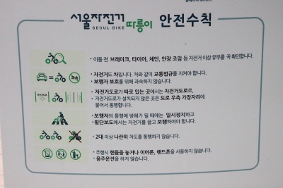 http://hongemama.tistory.com/26
출처
네이버 백과사전
구글 맵
서울자전거 따릉이 공식 웹페이지


https://creativecommons.org/about/downloads


