 따릉이 공식웹페이지
https://www.flickr.com/photos/142036864@N07/33089668054/in/photolist-21UBJU6-Sq2cub-29qHgod-zVhhu1-yMmF2V-zrBBnQ-yS9NK4-zFVPjb-zrBAWQ-zFVMFb-zrJ5NZ-zH8v75-28b6LPE-293R3tQ-PnkPY2-Nm646t-2d2c6hh-29NAUbX-2bQfavf
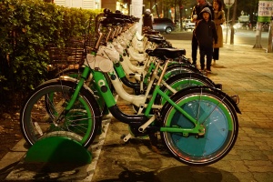
따릉이란?
- 서울시가 운영하는 자전거 무인 대여 시스템으로, 2015년 10월 직장인들의 출·퇴근 시 이용을 도와 자전거 교통 분담률을 높이고 친환경 자전거 도시를 만든다는 일환으로 실시됐다.
- 지하철 출입구·버스정류장·관공서·학교 등 접근이 쉬운 통행 장소 등에 대여소가 설치되어있으며, 대여소에서 따릉이의 대여와 반납이 무인으로 이뤄지며, 이용자들이 장소에 구애받지 않고 대여소가 설치된 곳이면 어디에서나 자전거를 대여하고 반납할 수 있다는 점이 특징이다.
이용방법
이용권 가격
7일권 일반(1시간) 3000원, 프리미엄(2시간) 4000원

30일권 일반(1시간) 5000원, 프리미엄(2시간) 7000원

180일권 일반(1시간) 15000원, 프리미엄(2시간) 20000원

365일권 일반(1시간) 30000원, 프리미엄(2시간) 40000원
일일권은 일반(1시간) 1000원, 프리미엄(2시간) 2000원이다. 이용시간은 이용권 해당 시간에 따라 적용되고 이용시간 초과시 20분당 500원의 추가 요금이 부과된다.
대여
어플 설치 후 1.회원가입 2.이용권구매 3.지도에서 대여소 선택 4.대여요청 5.단말기 홈버튼 선택
어플 설치 후 1.비회원 선택 2.따릉이 홈버튼 누르기 3.대여번호 입력 선택 4.대여번호 8자리 중 앞 4자리 입력 5.대여번호 8자리 중 뒤 4자리 입력
반납
1.반납할 대여소에 방문
2.빈 거치대에 자전거를 거치함
3.거치대의 잠금 장치를 자전거 단말기 우측에 연결하여 자전거를 잠금
4.자전거 단말기에서 “반납 완료”안내가 나오면 반납이 완료된 것 (반납 완료는 SMS로도 발송됨)
성북구 역근처 대여소 위치
한성대입구역 2번출구
서울특별시 성북구 동소문로 2 성북구 동소문동2가 2-3
지도를 불러오는 중...
{"minzoom":false,"maxzoom":false,"mappingservice":"googlemaps3","type":"ROADMAP","types":["ROADMAP","SATELLITE","HYBRID","TERRAIN"],"width":"300px","height":"300px","centre":false,"title":"","label":"","icon":"http://maps.google.com/mapfiles/marker.png","visitedicon":"","lines":[],"polygons":[],"circles":[],"rectangles":[],"wmsoverlay":false,"copycoords":false,"static":false,"zoom":12,"layers":[],"controls":["pan","zoom","type","scale","streetview"],"zoomstyle":"DEFAULT","typestyle":"DEFAULT","autoinfowindows":false,"resizable":false,"kmlrezoom":false,"poi":true,"markercluster":false,"clustergridsize":60,"clustermaxzoom":20,"clusterzoomonclick":true,"clusteraveragecenter":true,"clusterminsize":2,"tilt":0,"imageoverlays":[],"kml":[],"gkml":[],"fusiontables":[],"searchmarkers":"","enablefullscreen":false,"locations":[{"text":"\u003Cb\u003E\u003Cdiv class=\"mw-parser-output\"\u003E\u003C/div\u003E\u003C/b\u003E\u003Chr /\u003E\u003Cdiv class=\"mw-parser-output\"\u003E\u003C/div\u003E","title":"","link":"","lat":37.588412,"lon":127.006679,"icon":"http://maps.google.com/mapfiles/marker.png","inlineLabel":"\ud55c\uc131\ub300\uc785\uad6c\uc5ed 2\ubc88\ucd9c\uad6c\n"}]}
한성대입구역 6번출구 뒤
서울특별시 성북구 동소문로 1 한성대입구역 6번출구 뒤
지도를 불러오는 중...
{"minzoom":false,"maxzoom":false,"mappingservice":"googlemaps3","type":"ROADMAP","types":["ROADMAP","SATELLITE","HYBRID","TERRAIN"],"width":"300px","height":"300px","centre":false,"title":"","label":"","icon":"http://maps.google.com/mapfiles/marker.png","visitedicon":"","lines":[],"polygons":[],"circles":[],"rectangles":[],"wmsoverlay":false,"copycoords":false,"static":false,"zoom":12,"layers":[],"controls":["pan","zoom","type","scale","streetview"],"zoomstyle":"DEFAULT","typestyle":"DEFAULT","autoinfowindows":false,"resizable":false,"kmlrezoom":false,"poi":true,"markercluster":false,"clustergridsize":60,"clustermaxzoom":20,"clusterzoomonclick":true,"clusteraveragecenter":true,"clusterminsize":2,"tilt":0,"imageoverlays":[],"kml":[],"gkml":[],"fusiontables":[],"searchmarkers":"","enablefullscreen":false,"locations":[{"text":"\u003Cb\u003E\u003Cdiv class=\"mw-parser-output\"\u003E\u003C/div\u003E\u003C/b\u003E\u003Chr /\u003E\u003Cdiv class=\"mw-parser-output\"\u003E\u003C/div\u003E","title":"","link":"","lat":37.588727,"lon":127.006181,"icon":"http://maps.google.com/mapfiles/marker.png","inlineLabel":"\ud55c\uc131\ub300\uc785\uad6c\uc5ed 6\ubc88\ucd9c\uad6c \ub4a4\n"}]}
월곡역 3번출구
서울특별시 성북구 월곡로 지하 107 성북구 하월곡동 37-4
지도를 불러오는 중...
{"minzoom":false,"maxzoom":false,"mappingservice":"googlemaps3","type":"ROADMAP","types":["ROADMAP","SATELLITE","HYBRID","TERRAIN"],"width":"300px","height":"300px","centre":false,"title":"","label":"","icon":"http://maps.google.com/mapfiles/marker.png","visitedicon":"","lines":[],"polygons":[],"circles":[],"rectangles":[],"wmsoverlay":false,"copycoords":false,"static":false,"zoom":12,"layers":[],"controls":["pan","zoom","type","scale","streetview"],"zoomstyle":"DEFAULT","typestyle":"DEFAULT","autoinfowindows":false,"resizable":false,"kmlrezoom":false,"poi":true,"markercluster":false,"clustergridsize":60,"clustermaxzoom":20,"clusterzoomonclick":true,"clusteraveragecenter":true,"clusterminsize":2,"tilt":0,"imageoverlays":[],"kml":[],"gkml":[],"fusiontables":[],"searchmarkers":"","enablefullscreen":false,"locations":[{"text":"\u003Cb\u003E\u003Cdiv class=\"mw-parser-output\"\u003E\u003C/div\u003E\u003C/b\u003E\u003Chr /\u003E\u003Cdiv class=\"mw-parser-output\"\u003E\u003C/div\u003E","title":"","link":"","lat":37.602538,"lon":127.041593,"icon":"http://maps.google.com/mapfiles/marker.png","inlineLabel":"\uc6d4\uace1\uc5ed 3\ubc88\ucd9c\uad6c\n"}]}
월곡역 입구 육교 밑
서울특별시 성북구 월곡로 지하 107 성북구 종암동 113-10
지도를 불러오는 중...
{"minzoom":false,"maxzoom":false,"mappingservice":"googlemaps3","type":"ROADMAP","types":["ROADMAP","SATELLITE","HYBRID","TERRAIN"],"width":"300px","height":"300px","centre":false,"title":"","label":"","icon":"http://maps.google.com/mapfiles/marker.png","visitedicon":"","lines":[],"polygons":[],"circles":[],"rectangles":[],"wmsoverlay":false,"copycoords":false,"static":false,"zoom":12,"layers":[],"controls":["pan","zoom","type","scale","streetview"],"zoomstyle":"DEFAULT","typestyle":"DEFAULT","autoinfowindows":false,"resizable":false,"kmlrezoom":false,"poi":true,"markercluster":false,"clustergridsize":60,"clustermaxzoom":20,"clusterzoomonclick":true,"clusteraveragecenter":true,"clusterminsize":2,"tilt":0,"imageoverlays":[],"kml":[],"gkml":[],"fusiontables":[],"searchmarkers":"","enablefullscreen":false,"locations":[{"text":"\u003Cb\u003E\u003Cdiv class=\"mw-parser-output\"\u003E\u003C/div\u003E\u003C/b\u003E\u003Chr /\u003E\u003Cdiv class=\"mw-parser-output\"\u003E\u003C/div\u003E","title":"","link":"","lat":37.601406,"lon":127.041304,"icon":"http://maps.google.com/mapfiles/marker.png","inlineLabel":"\uc6d4\uace1\uc5ed \uc785\uad6c \uc721\uad50 \ubc11\n"}]}
길음역 3번출구 뒤
서울특별시 성북구 동소문로 248 동소문로248
지도를 불러오는 중...
{"minzoom":false,"maxzoom":false,"mappingservice":"googlemaps3","type":"ROADMAP","types":["ROADMAP","SATELLITE","HYBRID","TERRAIN"],"width":"300px","height":"300px","centre":false,"title":"","label":"","icon":"http://maps.google.com/mapfiles/marker.png","visitedicon":"","lines":[],"polygons":[],"circles":[],"rectangles":[],"wmsoverlay":false,"copycoords":false,"static":false,"zoom":12,"layers":[],"controls":["pan","zoom","type","scale","streetview"],"zoomstyle":"DEFAULT","typestyle":"DEFAULT","autoinfowindows":false,"resizable":false,"kmlrezoom":false,"poi":true,"markercluster":false,"clustergridsize":60,"clustermaxzoom":20,"clusterzoomonclick":true,"clusteraveragecenter":true,"clusterminsize":2,"tilt":0,"imageoverlays":[],"kml":[],"gkml":[],"fusiontables":[],"searchmarkers":"","enablefullscreen":false,"locations":[{"text":"\u003Cb\u003E\u003Cdiv class=\"mw-parser-output\"\u003E\u003C/div\u003E\u003C/b\u003E\u003Chr /\u003E\u003Cdiv class=\"mw-parser-output\"\u003E\u003C/div\u003E","title":"","link":"","lat":37.602703,"lon":127.024517,"icon":"http://maps.google.com/mapfiles/marker.png","inlineLabel":"\uae38\uc74c\uc5ed 3\ubc88\ucd9c\uad6c \ub4a4\n"}]}
상월곡역 4번출구
서울특별시 성북구 화랑로 148 성북구 상월곡동 산7-1
지도를 불러오는 중...
{"minzoom":false,"maxzoom":false,"mappingservice":"googlemaps3","type":"ROADMAP","types":["ROADMAP","SATELLITE","HYBRID","TERRAIN"],"width":"300px","height":"300px","centre":false,"title":"","label":"","icon":"http://maps.google.com/mapfiles/marker.png","visitedicon":"","lines":[],"polygons":[],"circles":[],"rectangles":[],"wmsoverlay":false,"copycoords":false,"static":false,"zoom":12,"layers":[],"controls":["pan","zoom","type","scale","streetview"],"zoomstyle":"DEFAULT","typestyle":"DEFAULT","autoinfowindows":false,"resizable":false,"kmlrezoom":false,"poi":true,"markercluster":false,"clustergridsize":60,"clustermaxzoom":20,"clusterzoomonclick":true,"clusteraveragecenter":true,"clusterminsize":2,"tilt":0,"imageoverlays":[],"kml":[],"gkml":[],"fusiontables":[],"searchmarkers":"","enablefullscreen":false,"locations":[{"text":"\u003Cb\u003E\u003Cdiv class=\"mw-parser-output\"\u003E\u003C/div\u003E\u003C/b\u003E\u003Chr /\u003E\u003Cdiv class=\"mw-parser-output\"\u003E\u003C/div\u003E","title":"","link":"","lat":37.605531,"lon":127.047268,"icon":"http://maps.google.com/mapfiles/marker.png","inlineLabel":"\uc0c1\uc6d4\uace1\uc5ed 4\ubc88\ucd9c\uad6c\n"}]}
상월곡역 1번출구
서울특별시 성북구 화랑로 지하 157 성북구 상월곡동 35-9
지도를 불러오는 중...
{"minzoom":false,"maxzoom":false,"mappingservice":"googlemaps3","type":"ROADMAP","types":["ROADMAP","SATELLITE","HYBRID","TERRAIN"],"width":"300px","height":"300px","centre":false,"title":"","label":"","icon":"http://maps.google.com/mapfiles/marker.png","visitedicon":"","lines":[],"polygons":[],"circles":[],"rectangles":[],"wmsoverlay":false,"copycoords":false,"static":false,"zoom":12,"layers":[],"controls":["pan","zoom","type","scale","streetview"],"zoomstyle":"DEFAULT","typestyle":"DEFAULT","autoinfowindows":false,"resizable":false,"kmlrezoom":false,"poi":true,"markercluster":false,"clustergridsize":60,"clustermaxzoom":20,"clusterzoomonclick":true,"clusteraveragecenter":true,"clusterminsize":2,"tilt":0,"imageoverlays":[],"kml":[],"gkml":[],"fusiontables":[],"searchmarkers":"","enablefullscreen":false,"locations":[{"text":"\u003Cb\u003E\u003Cdiv class=\"mw-parser-output\"\u003E\u003C/div\u003E\u003C/b\u003E\u003Chr /\u003E\u003Cdiv class=\"mw-parser-output\"\u003E\u003C/div\u003E","title":"","link":"","lat":37.605905,"lon":127.047134,"icon":"http://maps.google.com/mapfiles/marker.png","inlineLabel":"\uc0c1\uc6d4\uace1\uc5ed 1\ubc88\ucd9c\uad6c\n"}]}
상월곡역 3번출구
서울특별시 성북구 화랑로 지하 157 성북구 상월곡동 26-1
지도를 불러오는 중...
{"minzoom":false,"maxzoom":false,"mappingservice":"googlemaps3","type":"ROADMAP","types":["ROADMAP","SATELLITE","HYBRID","TERRAIN"],"width":"300px","height":"300px","centre":false,"title":"","label":"","icon":"http://maps.google.com/mapfiles/marker.png","visitedicon":"","lines":[],"polygons":[],"circles":[],"rectangles":[],"wmsoverlay":false,"copycoords":false,"static":false,"zoom":12,"layers":[],"controls":["pan","zoom","type","scale","streetview"],"zoomstyle":"DEFAULT","typestyle":"DEFAULT","autoinfowindows":false,"resizable":false,"kmlrezoom":false,"poi":true,"markercluster":false,"clustergridsize":60,"clustermaxzoom":20,"clusterzoomonclick":true,"clusteraveragecenter":true,"clusterminsize":2,"tilt":0,"imageoverlays":[],"kml":[],"gkml":[],"fusiontables":[],"searchmarkers":"","enablefullscreen":false,"locations":[{"text":"\u003Cb\u003E\u003Cdiv class=\"mw-parser-output\"\u003E\u003C/div\u003E\u003C/b\u003E\u003Chr /\u003E\u003Cdiv class=\"mw-parser-output\"\u003E\u003C/div\u003E","title":"","link":"","lat":37.60728,"lon":127.050567,"icon":"http://maps.google.com/mapfiles/marker.png","inlineLabel":"\uc0c1\uc6d4\uace1\uc5ed 3\ubc88\ucd9c\uad6c\n"}]}
석계역 5번출구 건너편
서울특별시 노원구 화랑로 지하 347-1 성북구 석관동 134-4
지도를 불러오는 중...
{"minzoom":false,"maxzoom":false,"mappingservice":"googlemaps3","type":"ROADMAP","types":["ROADMAP","SATELLITE","HYBRID","TERRAIN"],"width":"300px","height":"300px","centre":false,"title":"","label":"","icon":"http://maps.google.com/mapfiles/marker.png","visitedicon":"","lines":[],"polygons":[],"circles":[],"rectangles":[],"wmsoverlay":false,"copycoords":false,"static":false,"zoom":12,"layers":[],"controls":["pan","zoom","type","scale","streetview"],"zoomstyle":"DEFAULT","typestyle":"DEFAULT","autoinfowindows":false,"resizable":false,"kmlrezoom":false,"poi":true,"markercluster":false,"clustergridsize":60,"clustermaxzoom":20,"clusterzoomonclick":true,"clusteraveragecenter":true,"clusterminsize":2,"tilt":0,"imageoverlays":[],"kml":[],"gkml":[],"fusiontables":[],"searchmarkers":"","enablefullscreen":false,"locations":[{"text":"\u003Cb\u003E\u003Cdiv class=\"mw-parser-output\"\u003E\u003C/div\u003E\u003C/b\u003E\u003Chr /\u003E\u003Cdiv class=\"mw-parser-output\"\u003E\u003C/div\u003E","title":"","link":"","lat":37.613583,"lon":127.065773,"icon":"http://maps.google.com/mapfiles/marker.png","inlineLabel":"\uc11d\uacc4\uc5ed 5\ubc88\ucd9c\uad6c \uac74\ub108\ud3b8\n"}]}
성북구 그 외 대여소 위치
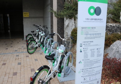
금호어울림센터힐 내
서울특별시 성북구 동소문로34길 73 금호어울림센터힐 내
지도를 불러오는 중...
{"minzoom":false,"maxzoom":false,"mappingservice":"googlemaps3","type":"ROADMAP","types":["ROADMAP","SATELLITE","HYBRID","TERRAIN"],"width":"300px","height":"300px","centre":false,"title":"","label":"","icon":"http://maps.google.com/mapfiles/marker.png","visitedicon":"","lines":[],"polygons":[],"circles":[],"rectangles":[],"wmsoverlay":false,"copycoords":false,"static":false,"zoom":12,"layers":[],"controls":["pan","zoom","type","scale","streetview"],"zoomstyle":"DEFAULT","typestyle":"DEFAULT","autoinfowindows":false,"resizable":false,"kmlrezoom":false,"poi":true,"markercluster":false,"clustergridsize":60,"clustermaxzoom":20,"clusterzoomonclick":true,"clusteraveragecenter":true,"clusterminsize":2,"tilt":0,"imageoverlays":[],"kml":[],"gkml":[],"fusiontables":[],"searchmarkers":"","enablefullscreen":false,"locations":[{"text":"\u003Cb\u003E\u003Cdiv class=\"mw-parser-output\"\u003E\u003C/div\u003E\u003C/b\u003E\u003Chr /\u003E\u003Cdiv class=\"mw-parser-output\"\u003E\u003C/div\u003E","title":"","link":"","lat":37.60076,"lon":127.024234,"icon":"http://maps.google.com/mapfiles/marker.png","inlineLabel":"\uae08\ud638\uc5b4\uc6b8\ub9bc\uc13c\ud130\ud790 \ub0b4\n"}]}
 http://www.sharehub.kr/sharestory/news_view.do?storySeq=161
- 따릉이가 있는 101동 앞은 원래 자전거 거치대가 있었으나, 관리가 되지 못하여 고장 난 자전거, 주인 없는 자전거 등으로 골칫거리였는데
이곳을 서울시가 직접 관리하는 따릉이 거치대로 변경하여 미관 문제도 해결하고, 많은 사람이 이용할 수 있는 자전거를 확보할 수 있게 되었다.
주의사항


 http://www.sharehub.kr/sharestory/news_view.do?storySeq=161