|
|
| 33번째 줄: |
33번째 줄: |
| | 36.99796, 128.68720 | | 36.99796, 128.68720 |
| | |service=googlemaps3 | | |service=googlemaps3 |
| − | |width=500 | + | |width=400 |
| − | |height=500 | + | |height=400 |
| | |type=normal | | |type=normal |
| | |overlays=videos-1,wikipedia | | |overlays=videos-1,wikipedia |
| 52번째 줄: |
52번째 줄: |
| | *'''소재지''' | | *'''소재지''' |
| | 경상북도 영주시 부석사로 345 (부석면, 부석사) | | 경상북도 영주시 부석사로 345 (부석면, 부석사) |
| | + | {{ |
| | + | #display_map: |
| | + | Seoul City; |
| | + | 36.99897725643355, 128.68745919391458 |
| | + | |service=googlemaps3 |
| | + | |width=300 |
| | + | |height=300 |
| | + | |type=normal |
| | + | |overlays=videos-1,wikipedia |
| | + | |icon=http://maps.google.com/mapfiles/marker.png |
| | + | |zoom=15 |
| | + | }} |
| | *'''종류''' | | *'''종류''' |
| | 건축물 | | 건축물 |
소개
창건시기
신라 문무대왕 16년(676년)에 의상이 왕명을 받아 세운 화엄종 사찰
위치
경상북도 영주시 부석면 봉황산 중턱
지도를 불러오는 중...
{"minzoom":false,"maxzoom":false,"mappingservice":"googlemaps3","type":"ROADMAP","types":["ROADMAP","SATELLITE","HYBRID","TERRAIN"],"width":"400px","height":"400px","centre":false,"title":"","label":"","icon":"http://maps.google.com/mapfiles/marker.png","visitedicon":"","lines":[],"polygons":[],"circles":[],"rectangles":[],"wmsoverlay":false,"copycoords":false,"static":false,"zoom":15,"layers":[],"controls":["pan","zoom","type","scale","streetview"],"zoomstyle":"DEFAULT","typestyle":"DEFAULT","autoinfowindows":false,"resizable":false,"kmlrezoom":false,"poi":true,"markercluster":false,"clustergridsize":60,"clustermaxzoom":20,"clusterzoomonclick":true,"clusteraveragecenter":true,"clusterminsize":2,"tilt":0,"imageoverlays":[],"kml":[],"gkml":[],"fusiontables":[],"searchmarkers":"","enablefullscreen":false,"locations":[{"text":"\u003Cb\u003E\u003Cdiv class=\"mw-parser-output\"\u003E\u003C/div\u003E\u003C/b\u003E\u003Chr /\u003E\u003Cdiv class=\"mw-parser-output\"\u003E\u003C/div\u003E","title":"","link":"","lat":36.99796,"lon":128.6872,"icon":"http://maps.google.com/mapfiles/marker.png"}]}
유래
의상은 용이 바위로 변하여서 절을 지을 수 있도록 하였다고 해서 절 이름을 부석사로 하였다고 함
구조
무량수전
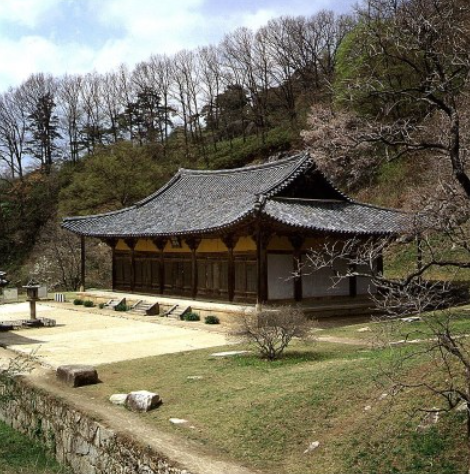
국보
제 18호
경상북도 영주시 부석사로 345 (부석면, 부석사)
지도를 불러오는 중...
{"minzoom":false,"maxzoom":false,"mappingservice":"googlemaps3","type":"ROADMAP","types":["ROADMAP","SATELLITE","HYBRID","TERRAIN"],"width":"300px","height":"300px","centre":false,"title":"","label":"","icon":"http://maps.google.com/mapfiles/marker.png","visitedicon":"","lines":[],"polygons":[],"circles":[],"rectangles":[],"wmsoverlay":false,"copycoords":false,"static":false,"zoom":15,"layers":[],"controls":["pan","zoom","type","scale","streetview"],"zoomstyle":"DEFAULT","typestyle":"DEFAULT","autoinfowindows":false,"resizable":false,"kmlrezoom":false,"poi":true,"markercluster":false,"clustergridsize":60,"clustermaxzoom":20,"clusterzoomonclick":true,"clusteraveragecenter":true,"clusterminsize":2,"tilt":0,"imageoverlays":[],"kml":[],"gkml":[],"fusiontables":[],"searchmarkers":"","enablefullscreen":false,"locations":[{"text":"\u003Cb\u003E\u003Cdiv class=\"mw-parser-output\"\u003E\u003C/div\u003E\u003C/b\u003E\u003Chr /\u003E\u003Cdiv class=\"mw-parser-output\"\u003E\u003C/div\u003E","title":"","link":"","lat":36.998977256434,"lon":128.68745919391,"icon":"http://maps.google.com/mapfiles/marker.png"}]}
건축물
정면 5칸, 측면 3칸

